Digital Earth Africa’s Capacity Development Webinar
Bringing together key partners of the DE Africa program along with nearly 200 passionate members of the DE Africa community, our latest webinar focused on Capacity Development and…01 Mar 2021

Digital Earth Africa, FrontierSI, COOi Studios and NGIS announce partnership to undertake Industry Engagement Study in Africa
DE Africa’s Industry Engagement Study will provide vital insight into how African industry is engaging with satellite imagery, with a particular focus on African organisations…01 Mar 2021

Intelligent Agriculture
How Digital Earth Africa is supporting sustainable coffee production in Kenya The DE Africa platform provides free and open data covering the continent of Africa, the…29 Jan 2021

Digital Earth Africa has the potential to contribute billions to the African economy using Earth observations
Across the world, Earth observations (EO) are used to by industry and government to improve environmental, agricultural and community outcomes. In Africa, they represent the…15 Jan 2021

Thank You Africa Regional Data Cube
After two and half years of successful operation, the Africa Regional Data Cube (ARDC) will be decommissioned as we transition to Digital Earth Africa (DE Africa) - a major…19 Nov 2020

Data moves to Cape Town
A cloud-free image of all of Africa produced by combining tens of thousands of satellite image collected throughout an entire year. The new AWS data centre in Cape Town stores…13 Nov 2020

Cane Poaching, By Stephen Korir
The sugar industry in Africa has had its fair share of seasonal challenges and problems, ranging from fragmentation of lands making it uneconomical for small holder farmers,…04 Nov 2020
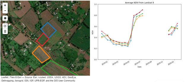
Mapping crop phenology key to addressing food security in Kenya, by Stephen Korir
The agricultural sector is a major driver of Kenya’s economy and a source of livelihood for most of the population. The agriculture sector plays a key role in reducing poverty and…04 Nov 2020

Analysis Ready Data for Africa
Satellites have continually captured Africa’s land surface and coastlines for decades, but it has proven difficult to translate this into usable information. The key question…16 Sep 2020

Putting Africa on the radar
We’re working to make Copernicus Sentinel-1 radar satellite data available in an analysis-ready format within the Digital Earth Africa platform by the end of 2020. For the first…07 Sep 2020