The South African Environmental Observation Network (SAEON) recently highlighted the power of Digital Earth Africa’s tools in the management and mitigation of South Africa’s coastal risks and hazards.
In an article entitled “Understanding Coastal Risk and Vulnerability in South Africa”, SAEON investigates the critical issues of coastal risk and vulnerability in South Africa, emphasising the importance of proactive monitoring and sustainable management practices.
The article highlights, in part, how tools – such as Digital Earth Africa’s coastlines Github notebook and Digital Earth Africa coastlines Jupyter Notebook - enable raw earth observation data to be turned into decision-ready products to help inform policy and drive action.
Coastal risk and vulnerability in South Africa
South Africa boasts a diverse and extensive coastline stretching 2,798 kilometres along the Atlantic and Indian Oceans. This unique coastal landscape, while rich in biodiversity, is subject to increasing risks and vulnerabilities stemming from global phenomena such as climate change and environmental degradation. The coastal areas of South Africa face various risks, including coastal erosion, flooding, and sea-level rise driven by climate change. The consequences of these risks extend beyond negative environmental impacts and includes health-related and socio-economic repercussions. The vulnerability of South Africa's coastlines underscores the urgent need for comprehensive strategies to manage and mitigate coastal risks and hazards.
The persistent challenge of coastal erosion
Coastal erosion, characterised by the gradual loss of coastline due to both natural and human-induced factors, presents a long-term hazard to coastal communities. Natural forces such as wave energy and climate change-induced sea-level rise, coupled with human activities such as urbanisation and sand mining, contribute to this phenomenon.
The consequences of coastal erosion are far-reaching. Economically, erosion results in the loss of valuable coastal property and infrastructure, impacting communities reliant on coastal resources such as fisheries. Environmentally, coastal erosion jeopardises habitats which are critical for biodiversity and coastal protection, amplifying the regions vulnerability to natural disasters such as storm surges.
Monitoring and managing coastal erosion
In the task of addressing coastal erosion effectively, advanced technologies, such as Geographic Information Systems (GIS) and Remote Sensing, can play a crucial role. These tools provide invaluable data on coastal dynamics, enabling informed decision-making for sustainable coastal management and related erosion control.
Remote sensing platforms like Digital Earth Africa enable continuous monitoring of coastal changes, offering insights into erosion trends and supporting proactive interventions. Using the publicly available tools offered by Digital Earth Africa, stakeholders can monitor these coastline changes.
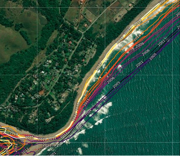
Understanding the capabilities of DE Africa’s tools particularly around coastal erosion can be demonstrated through particular critical events along the KwaZulu-Natal (KZN) coastline. SAEON’s deep-dive article includes events in 2006 and 2007 and 2011 which underscored the impact of erosion exacerbated by wave dynamics and reduced sediment supply.
In this case study, the Digital Earth Africa notebook was used to assess trends in coastal expansion and erosion for the coast of KZN near the Tugela River mouth. Digital Earth Africa Coastlines is a continental dataset that consists of annual shorelines and rates of coastal change for the whole African coastline. The product merges satellite data from the Digital Earth Africa program with tidal modelling to map the typical location of the coastline at mean sea level each year. The tool makes it possible to assess trends in coastal expansion and erosion at both the local and continental scales, enabling historical mapping of coastal change patterns to be updated regularly as new data is obtained. This enables current rates of coastal change to be compared with those observed in previous years or decades.
The ability to map the positions of the shoreline every year offers an important understanding of whether changes to the coastline are a result of one-time occurrences or a longer-term pattern of steady developments.
The results of the Digital Earth Africa coastline indicate that this coastline near Tugela River mouth has retreated by – 14 metres (+-1.5) per year on average since the year 2000. The shoreline in the area of the Tugela River mouth was the most seaward in 2003, and most landward in 2020. Since the year 2000, the median annual position of the shoreline has moved a distance of approximately 257 metres. This shows a clear long-term pattern of coastal erosion, that, without proactive measures being implemented, will devastate the local community and tourism in the area.
Towards sustainable coastal management
It is clear that coastal regions globally are facing escalating risks from erosion and other hazards. Through leveraging technology and data-driven approaches, governments and other stakeholders can develop adaptive strategies to mitigate these risks and build resilient coastal communities. The case of KwaZulu-Natal highlights the importance of proactive monitoring and collaboration in safeguarding our coastlines for future generations.
The image indicating the retreat of the Tugela River mouth using the Digital Earth Africa Coastlines map included in this article has been taken from those included in the SAEON article.
To find out more about the Digital Earth Africa coastlines products and how these could benefit your organisation, programme or company, contact communications@digitalearthafrica.org