Flooding is a significant and recurring disaster in Kogi State, Nigeria, which lies at the confluence of the Niger and Benue Rivers. This geographical location, coupled with the seasonal release of water from the Lagdo Dam in Cameroon, makes Kogi highly susceptible to severe flooding. With the frequency of floods increasing over the years, including major events in 1994, 2004, 2012, and more recently, in 2020, and again in October 2024, flood management has become a critical concern for the state.
Enhancing preparedness against disaster
Traditional methods have proven inadequate in managing flood risks, which is why geospatial technologies such as Geographic Information Systems (GIS) and remote sensing are being explored to enhance flood risk assessment, evacuation planning, and disaster management in the region.
Research developed by Juliet Ibenegu and Japhets President Odumije focuses on leveraging GIS and remote sensing data to assess flood risks in Kogi State and to develop flood evacuation plans. The goal is to provide local authorities with detailed tools for flood preparedness, risk reduction, and effective response to flood events.
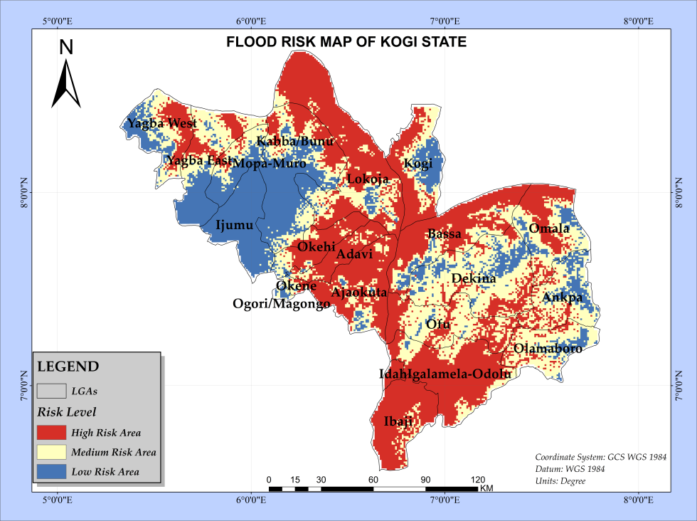
GIS-based hydrological models were used to identify areas at high, medium, and low flood risk. Key factors such as elevation, proximity to water bodies, land cover, and population density were taken into account.
High-risk areas were identified in low-lying regions near the Niger and Benue Rivers, including Lokoja, Idah, and Ibaji, which face severe inundation, especially during peak rainfall and dam releases. Conversely, higher-elevation regions like Kabba and Ogori Magongo are at lower risk of flooding. In addition to risk mapping, GIS was used to create evacuation route maps. The analysis showed that flood-prone villages such as Idah and Ibaji have poor road connectivity, making evacuation difficult during flood events. Conversely, towns like Ajaokuta and Dekina have more robust road networks, though still face challenges during emergencies due to congestion or poor maintenance.
Digital Earth Africa used as gold standard for data validation
This study employed a comprehensive approach combining data collection, analysis, and application of geospatial techniques to assess flood risk and develop evacuation map for Kogi State. Ibenegu says that Digital Earth Africa data was used as the standard to cross-check the data.
This study utilised secondary data, sourced from ASTER SRTM data from USGS (2022), land use from ESA (2021), Kogi State boundaries from GRID3 (2023), road networks from HOT OSM (2022), and water bodies from OSM (2024). Population data was retrieved from the National Bureau of Statistics (2006 census).
Solutions, and challenges
The study’s results emphasize the critical role of geospatial technologies in flood risk management. GIS enables the identification of high-risk flood zones and provides actionable information to guide evacuation planning. For example, evacuation maps highlight accessible routes, safe zones, and vulnerable areas where roads may be impassable. These maps ensure timely evacuations, reducing the potential loss of life and property.
Ibenegu says that the challenges experienced when undertaking the research of this nature is increasingly necessary but requires pulling different and diverse data sets together. However, she says that the data is disparate and at times inaccessible, which makes it difficult to provide a holistic view that is so important in order to inform planning and risk mitigation strategies. She says, “Many institutions hold on to their information and are unwilling to give it up. Other information is outdated. This creates real challenges in being able to develop an accurate picture of the challenges and the human impact that they can cause.”
To enhance flood resilience in Kogi State, the study recommends that decision-makers integrate GIS-based flood risk maps into their disaster management strategies. This would improve evacuation planning, resource allocation, and emergency response. Furthermore, investment in GIS infrastructure, coupled with training for disaster management personnel, would ensure that local authorities are well-equipped to handle flood emergencies effectively. Ibenegu also says, “Kogi state has annual flooding. Each year, Cameroon releases water from the Lagdo dam into the Benue River which results in overflow of the river’s boundaries into populated areas in Kogi. This is an annual disaster that could be averted if decision-makers could see the extent of the impact on an annual basis.”
The application of geospatial technologies such as GIS and remote sensing plays a vital role in improving flood risk assessment, evacuation planning, and overall disaster management in Kogi State. The adoption of these technologies will not only enhance flood preparedness but also contribute to more resilient and sustainable communities in flood-prone areas. But it is up to Kogi State’s decision-makers to engage with the data to inform and prepare.
The research paper can be viewed here. It has been developed by Ekpereamaka Juliet Ibenegbu from the Department of Geoinformatics and Surveying, University of Nigeria and Japhets President Odumije, from the Department of Geography and Meteorology, Nnamdi Azikiwe University.