
In the course of our work at Digital Earth Africa we are always delighted when unexpected, positive outcomes present themselves to us. For Senior Science Advisor and PDDT lead, Dr Meghan Halabisky, such a serendipitous episode occurred when she found that our datasets extended into a tiny corner of Southern Spain, and presented new opportunities.
Dr Halabisky has been collaborating with a Spanish wetland remote sensing researcher, Ricardo Diaz-Delgado who spent this summer as a visiting scientist with the University of Washington Precision Forestry Cooperative. During his time they spoke about the famous Doñana wetlands where he works and both were delighted to find that the Digital Earth Africa datasets cover this southernmost region. Dr DIaz-Delgado did some analyses and was able to compare it to other datasets that exist for the Doñana, such as that of the Estación Biológica de Doñana
As the datasets are based on the Mueller et al. (2016) algorithm using Landsat images, imagery strips include Southern Spain. The three available products that can be used are: Daily Surface Water since 1984 for all available Landsat scenes over the area; an annual summary for mapped Water Surface, and; All-time Surface Water, provided in percent of wet over dry scenes.
Dr Diaz-Delgado explains that they provide yearly anomalies as a synoptic map to assess changes in natural inundation of Doñana marshes and water bodies (subtracting annual hydroperiod to the whole time series starting by 1984). But what is really revealing climate change and human actions for us is hydroperiod time series trend.
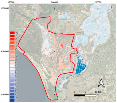
Theil–Sen slope in days/year showing the hydroperiod trend from 1974 to 2021. Red indicates consistent and significant decreasing trend in hydroperiod, while blue indicates the opposite (methods from Díaz-Delgado et al. 2016). The boundary of Doñana National Park is shown in red
The Doñana Wetlands are characterized by a mosaic of habitats, including marshes, lagoons, salt pans, and Mediterranean scrubland, which support a wide range of flora and fauna, especually migratory birds. The Doñana Wetlands have been recognized as a UNESCO World Heritage Site since 1994 and are considered one of the most important wetland ecosystems in Europe, playing a vital role in maintaining the region's ecological balance and supporting the local economy.
The Digital Earth Africa datasets receive high praise from Dr Diaz-Delgado, and him and Dr Halabisky see opportunities in sharing the data and augmenting the maps and reports needed. Validation can be done much easier as much of the data already exists within the datasets.