Researchers have provided an important analysis on feed balances of livestock using Digital Earth Africa’s cropland extent map along with other gridded data products. The results provide critical insight into the sustainability and management of ruminant livestock in Ethiopia and Burkina Faso.
Simon Fraval, one of the researchers involved in the study, believes that using Digital Earth Africa’s extent maps are ideal for studying the complex diversity of farm systems across Africa. He says, “With state-of-the-art data products, powerful compute resources and a familiar user interface, the Digital Earth Africa platform is a valuable enabler for scientific research.”
As well as accessing the Digital Earth Africa maps, the research team was able to work in Digital Earth Africa’s Sandbox environment as “power users”. On request, power users are provided at no charge with significantly more space in the Sandbox to enable the analysis of vast amounts of data that otherwise would not be possible in the standard Sandbox environment.
Background to the study
In sub-Saharan Africa (SSA), as populations increase there is a growing demand for animal-based foods. In countries where livelihoods and food security are significantly supported through livestock farming, it is critical for decision makers at local, sub-national and national levels to have a sound understanding of the availability of livestock feed.
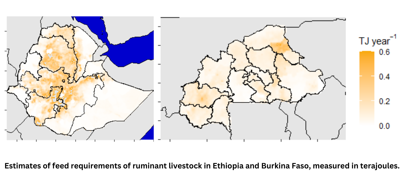
Researchers Simon Fraval and John Mutua, et al., conducted a study - entitled, “Feed balances for ruminant livestock: gridded estimates for data−constrained regions” - to assess feed balances (balancing the requirements of livestock feed with the amount of utilisable feed) for ruminant livestock in Ethiopia and Burkina Faso. Both these economies are primarily driven by agriculture, subsistence farming and livestock raising.
By 2019, Ethiopia had the largest livestock population in Africa, with over 70 million head of cattle, 40 million sheep and 50 million goats. These animals are mainly reared in highland mixed crop-livestock systems, as well as in pastoral or agro-pastoral systems. In the same year, Burkina Faso had 10 million cattle, 11 million sheep and 17 million goats. The bulk of Burkina Faso’s cattle population is reared in pastoral or agro-pastoral systems, followed to a lesser degree by semi-intensive systems and a small percentage reared in intensive systems.
The study area spanned the extent of Ethiopia’s 1.10 million km2 landmass in East Africa and Burkina Faso’s 0.27 million km2 landmass in West Africa.
EO data-supported analysis
Livestock feed availability has been modelled in many ways, with the most detailed analyses having been conducted at sub-national scales, integrating ground measurements and satellite-derived biomass estimates. (Biomass in this instance refers to the food-based portion of crops).
Fraval et al.’s study estimated biomass availability for ruminant livestock consumption using gridded products on a number of key factors. These included land use, above-ground dry matter (crop) productivity, the types of crops, cyclical environmental patterns, biomass burning, and protected area demarcations (such as national parks and reserves).
To estimate net dry matter productivity, and thus dry matter availability for consumption by ruminant livestock, the study used previously derived data from the Copernicus Land Monitoring service. The proportion of cropland in this product was found to under-represent arable land, so the study used the region-specific cropland extent product from Digital Earth Africa. Cropland extent was estimated to be representative of 2019 using Sentinel 2 imagery. The product was produced using over 25000 training samples across Africa and validated with 1800 samples over eight regions (ranging from 130 to 300 samples per region). Pixels classified as cropland were filtered using an object detection algorithm, which removed isolated cropland areas of less than 1 ha.
Findings
Feed scarcity hotspots were found to be most prominently located in the Ethiopian highlands and the Sahelian agro-ecological zone of Burkina Faso. This provides information that can drive critical actions; for example:
- Demand-side policy and investment initiatives can address hotspots by influencing herd sizes, nutritional requirements and herd mobility.
- Supply-side policy and investment initiatives can secure existing feed resources, develop new sources of feed and incentivise trade in feed resources.
Improving feed balances will be of value to decision-makers with the aim of optimising livestock productivity, minimising exposure to climatic shocks and minimising greenhouse gas emission intensity.
Next steps
Mutua and Fraval, et al. are currently working to scale up their approach to an additional three pilot countries; namely, Nigeria, Cameroon and Somalia.
This is being delivered through a collaboration between the African Union’s International Bureau for Animal Resources, the International Livestock Research Institute and the University of Edinburgh. These feed balance estimates will provide a new source of evidence for decision makers as they plan for more resilient, sustainable and equitable livestock systems.
Interacting with Digital Earth Africa’s platform
Fraval says that what sets the Digital Earth Africa’s platform apart from other online remote sensing platforms is its state-of-the-art products, powerful compute resources and the intuitive user interface. But there is more. He says, “The ethos and ecosystem around the core offering are well-aligned with initiatives that seek positive change for all of life inhabiting the African continent. This combination of quality and alignment is a unique offering.”
Further reading
To access the full study entitled, please click this link: “Feed balances for ruminant livestock: gridded estimates for data−constrained regions”.
About the authors of the study
 Simon Fraval is an independent consultant, specialising in environmental sustainability and human nutrition. With over 15 years of experience tackling food system challenges, Simon has made contributions to improving food security and sustainability in diverse regions, including Australia, the Netherlands, Central America, Indonesia, and sub-Saharan Africa.
Simon earned his PhD from Wageningen University and has been a post-doctoral research fellow at the University of Edinburgh, where he honed his expertise in integrating remotely sensed imagery with other data sources to support decision-making for more equitable and sustainable food systems.
The lead author’s work on this study was supported by a TRAIN@ED fellowship funded by the European Union’s Horizon 2020 research and innovation programme under the Marie Skłodowska-Curie grant agreement No 801215 and the University of Edinburgh Data-Driven Innovation programme, part of the Edinburgh and South East Scotland City Region Deal.
 John Mutua is a PhD candidate at the School of Geosciences and the Global Academy of Agriculture and Food Security, University of Edinburgh and a PhD fellow at the Jameel Observatory for Food Security Early Action . Prior to this, John worked as a geospatial analyst at the Alliance of Bioversity International and CIAT. His current research focuses on using spatial analysis and environmental modelling to inform decision making in crop and livestock systems.
For his PhD, John is using earth observation (EO) combined with local ground truth data to estimate livestock diet composition in East Africa. Data on livestock diets is needed in the livestock sector in East Africa to model accurate emissions estimates, predict feed requirements for improved feeding strategies, and as well guide interventions for communities at risk from droughts and other shocks.