In the rapidly evolving field of geospatial solutions, M.A.P. Scientific Services (MAPSS) is a powerful example of applying scientific knowledge and insight to real-world environmental challenges. Founded by a trio of visionary researchers from the University of Pretoria in 2017, Dr Pieter Olivier, Andrew Purdon and Michael Mole, the company has grown into a thriving enterprise that bridges the gap between scientific research and practical implementation. Their mission: to arm conservation organisations with insights from geospatial tools and earth observation data that enhance the protection and management of vast landscapes, particularly in under-resourced areas like national parks.
Andrew Purdon, an ecologist and geographic information system (GIS) specialist with a wealth of experience in conservation projects across Africa, says that the strategic use of partner Digital Earth Africa's expansive data resources, combined with the Environmental Systems Research Institute (ESRI) platform have been central to the success of MAPSS.
The synergistic partnership between Digital Earth Africa, a pioneering initiative that provides open access to a wealth of geospatial information across the African continent, and ESRI, an international supplier of GIS software, combines the strengths of both organisations to enhance geospatial capabilities across the African continent. This is evidenced in the work of MAPSS.
"Digital Earth Africa provides a vast repository of analysis-ready satellite data integrated with ESRI’s ArcGIS platform and accessible via the Africa GeoPortal," says Purdon. “This integration allows for sophisticated spatial analysis and visualisation, making it easier to monitor environmental changes, plan conservation efforts, and manage natural resources effectively. The data accessibility and advanced analytic tools help us to address the challenges we face in conservation." MAPSS is also part of the ESRI partner network.
Digital Earth Africa Sentinel-2 data
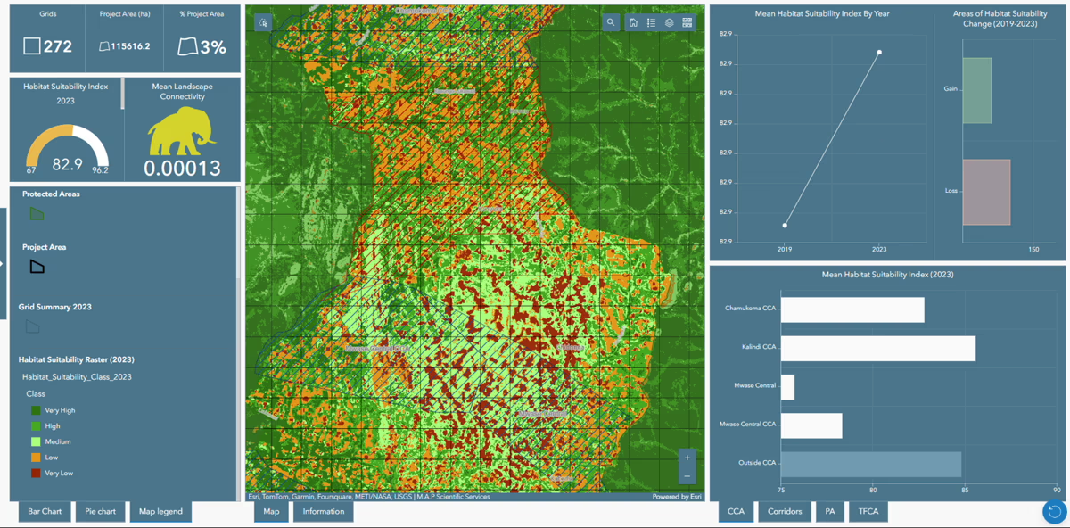
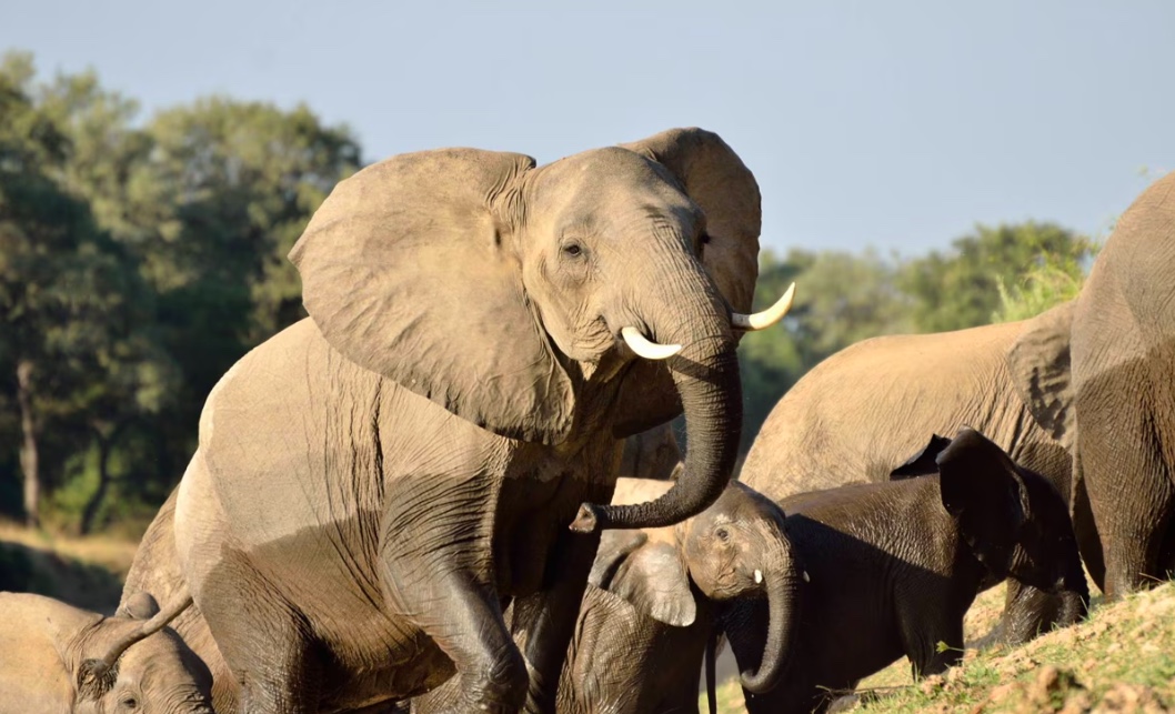
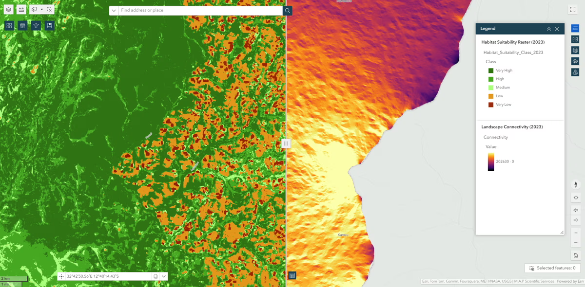
By harnessing Digital Earth Africa's Sentinel-2 data products and the ArcGIS platform, the company performs detailed land cover classifications that are essential for understanding environmental changes over time. This data enables the creation of predictive models that forecast land cover transformations and assess habitat suitability for various species, such as elephants. MAPSS analysis provides detailed insights into animal movements and habitat preferences, which is overlaid with data on human settlements and agricultural areas. MAPSS uses this data to design wildlife corridors, ensuring safe passage for animals like elephants, while minimising human-wildlife conflict.
"From land cover classifications, we can see how land cover has changed in the past, and predict how it will change in the future. We do predictive mapping, which could show approaching habitat loss and even predict changes in landscapes, wildlife movement and areas of overlap with human activities,” Purdon explains. “We'll use that land cover map as part of our habitat suitability projects to identify areas that elephants would typically use. From there, we can design wildlife corridors between these crucial areas."
The ability to predict changes in land use and habitat conditions further allows for targeted interventions that promote sustainability and biodiversity conservation. “If you define a corridor between two national parks, you ideally want to minimise habitat change within the corridor. Interventions are aimed at assisting communities to maintain natural habitats and reduce human wildlife conflict."
Impact and growth
The impact of these data-driven solutions is significant. MAPSS work supports large NGOs and government bodies in monitoring extensive landscapes, providing them with the spatial context needed for informed decision-making. By offering user-friendly solutions built on ESRI's technology to these organisations, MAPSS empowers even those without technical expertise to engage with complex geospatial data effectively. “Many organisations don't have the capacity to do these types of analysis, so being able to provide them with information to make informed decisions goes a long way,” says Purdon.
This approach has led to significant ecological benefits and fuelled the company's growth. MAPSS clients include prominent conservation organisations and its projects span across various African countries, including South Africa, Zambia, Zimbabwe, Botswana, Malawi, Tanzania, Kenya, Mozambique and Madagascar.
"From local conservation efforts to global environmental analyses, we’re providing data-driven solutions that not only inform but also inspire action," says Purdon. "Our work has contributed to habitat restoration, species protection, and the creation of sustainable land-use practices that balance human livelihoods with the conservation of biodiversity."
A model for private sector innovation
MAPSS shows how private sector entities can harness the power of Digital Earth Africa accessible data to drive impactful and sustainable business models. Their journey from a small research group to a key player in geospatial solutions highlights the potential for growth when companies leverage the insights from comprehensive data platforms to meet pressing environmental challenges.
As they continue to expand their reach and refine their solutions, MAPSS inspires other private sector organisations to explore the untapped potential of Digital Earth Africa. The future of conservation and sustainable development in Africa may well be shaped by innovative collaborations like these, where data and technology serve as catalysts for positive change.