Rwanda, similar to many other countries in sub-Saharan Africa, has been experiencing irregularities in rainfall and temperature, resulting in prolonged droughts, flooding events, and landslides, adversely impacting farming systems and food production. As agriculture is the backbone of Rwanda’s economy - providing livelihoods for over 70% of the population and contributing to about 33% of the country's GDP - this poses significant threats to food security and the socio-economic wellbeing of the population.
Emerging geospatial technologies which facilitate access to freely available images and cloud -based platforms for analysis of these - such as Digital Earth Africa - are critical to informing agricultural production under the changing climate conditions. In particular, these technologies enable frequent monitoring of large areas while avoiding costly field surveys and other resource-intensive interventions.
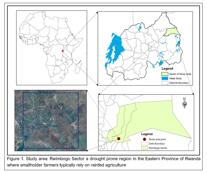
Research was recently conducted by Joel Ndayisaba, an Urban and Regional Planning graduate from the University of Rwanda, College of Science and Technology (UR-CST) to assess the impact of climate change on rural smallholder farmers in Rwanda, to inform effective adaptation and mitigation strategies. The impacts of climate change and variability on agriculture production have been notably higher in the rural areas of Rwanda, where smallholder farmers rely primarily on rain-fed agriculture for their livelihoods. The changing weather patterns have led to crop failures, reduced food production, increased poverty, and food insecurity.
As a starting point, a literature review was undertaken to develop the problem analysis, incorporating reports from various institutions. These included the Ministry of Agriculture and Animal Resources (MINAGRI), Rwanda Agriculture Board (RAB), the National Institute of Statistics of Rwanda (NISR) and the University of Rwanda (UR).
Spatial data to inform agricultural production under changing climate
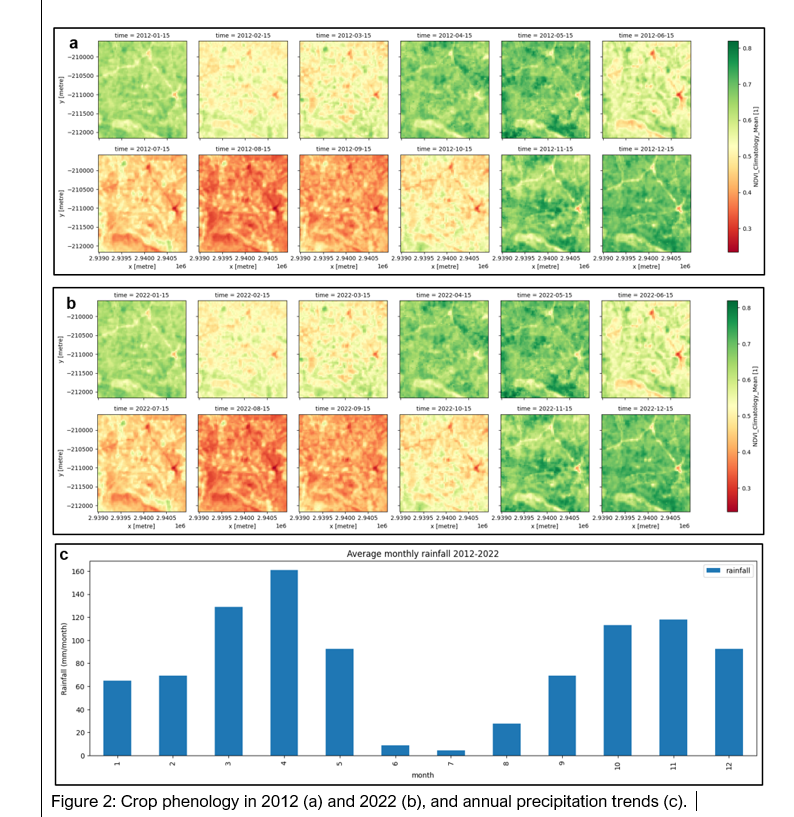
From a geospatial analysis perspective, the Normalized Difference Vegetation Index (NDVI) was selected as an indicator of crop health, which was derived from Landsat images that are freely accessible via the DE Africa platforms. These were combined with climate data to understand the effect of climatic factors on crop health and phenology in the Rwimbogo sector in the drought-prone Eastern Province of Rwanda.
Overall, the region is characterized by shortage in rainfall especially in the second (January-March) and fourth (June-August) seasons. For rain-fed crops, the trend in NDVI increased in the first (September-December) and third (March-May) seasons although a slight difference was noted between 2012 and 2022. The analysis of NDVI Climatology, Rainfall Distribution, Plot Standard Deviation NDVI Climatology, and Plot per Pixel Phenology underscores the pressing challenges of climate change-induced crop yield dynamics in the region.
A concerted effort towards mitigation and adaptation becomes imperative to effectively address these agricultural adversities in the Rwimbogo sector. Sustainable land management practices, such as agroforestry and conservation agriculture, offer a mitigation avenue by enhancing soil moisture retention and curbing erosion. Additionally, adopting drought-resistant crop varieties and diversification of crops can bolster resilience against climate variability, ultimately improving long-term food security.
Next steps
The current study relied on the remotely acquired datasets, and therefore, the next step will consist of field validation through crop extent, health and yield data.
The dissemination of the results, consisting of the comprehensive analysis of climatic trends and related effects on crop health and yield, will be followed by stakeholder engagement (local communities, government agencies, research institutions, and non-governmental organizations) for easy implementation of the proposed measures/strategies towards a more resilient and sustainable agricultural future in the face of changing climatic conditions.
Conclusion
The challenge of ensuring food-secure populations remains a challenge given climate change and seasonal variability. Through the National Strategy for Transformation (NST1) and Vision 2050, the Rwandan government intends to guarantee food security for the rapidly growing population while minimizing the adverse impacts of climate change. This is in line with global initiatives such as Sustainable Development Goal (SDG) 1-No poverty, 2-Zero hunger, and 13-Climate action.
This research aligns well with the ethos and intentions of the NSTI and Vision 2050, and demonstrates that combining emerging geospatial technologies, especially free and open-source platforms and less intensive field works, is critical to informed rain-fed agriculture in the study area and elsewhere in the country. In addition, collaboration and data sharing amongst key stakeholders would increase the accuracy of the results, whilst promoting the efficient use of resources invested in data field data acquisition, storage and processing.
Ultimately, research findings such as these can practically inform strategies to enhance resilience and sustainability of Rwanda's agricultural sector in response to climate change.
About the author
 Joel Ndayisaba is familiar with emerging technologies, particularly in Geospatial analysis, including GIS and Remote Sensing, with diverse skills in a variety of software and platforms, which include the desktop and online suite of Esri products.
He also has proficiency with platforms such as Digital Earth Africa, Google Earth Engine, GitHub and passionate about research, Joel has used these platforms in various research topics, including presentations at the GORILLA Conference and IBMA.