When the water supply to a large, bustling city such as Harare is threatened by decreasing oxygen levels, the use of technology - and specifically earth observation data - in order to map and predict concentrations of algal growth becomes critical. This was the approach used by Muongeni Manda, a Geoinformatics and Environmental Conservation postgraduate from Chinhoyi University of Technology, Zimbabwe.
Lake Chivero is a reservoir on the Manyame River in Zimbabwe. It provides the main water supply for Harare and is used for purposes of irrigation, fishing, and a habitat for birds. However, over the years the lake has faced ecological threats such as pollution, siltation and invasion of the fast-growing water hyacinth. These invasive aquatic plants are known to overrun bodies of water resulting in congested waterways and the death of submerged native plant species. The subsequent decay of native plants that depletes dissolved oxygen in the water is related to fish deaths and can have disastrous impacts on fishing communities. All the abovementioned threats to Chivero are related to urban growth due to it being situated downstream from Harare City and its surrounding settlements.
Chivero is home to a delicate ecosystem of shoreline vegetation and aquatic life, such as fish, invertebrates and plankton. It also includes the surrounding Miombo Woodlands that provide habitat to various local animal species, including white rhino, plains zebra, ground pangolins and numerous bird species. This delicately balanced ecosystem is prone to seasonal changes in the lake’s water levels, and the resultant water quality and salinity can have huge impacts on the water provided to the city of Harare.
DE Africa was used to study the changes in water extent and quality over time and made comparisons with rainfall data from Climate Hazards Group InfraRed Precipitation with Station (CHIRPS). The study finds that Lake Chivero’s water quality is declining due to increased levels of nutrient concentrations namely, nitrogen and phosphorus, a condition known as Eutrophication that can result in algal blooms degrading the water quality and aquatic life by depleting oxygen in the water. This condition is likely caused by urbanization and agricultural activity.
DE Africa’s Modified Normalised Difference Water Index (MNDWI) provided water extent from January 2017 to December 2023 in comparison with the rainfall data generated by CHIRPS, indicating drought in October 2020 and floods in early year 2021. The floods were a direct result of tropical cyclones Eloise 11 to 27 January 2021 and Guambe February 11 to 22 February 2021.
Figure 2: Lake Chivero using DE Africa Rolling Geomedian (L) - Lake Chivero: 2023 Rolling Geomedian in RGB (R) - Lake Chivero: 2023 Rolling Geomedian in MNDWI (Sentinel-2 data processed by Digital Earth Africa)

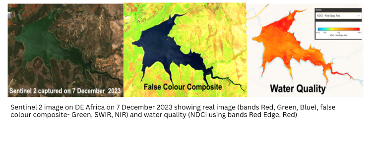
After measuring the water extent, water quality was estimated using the Normalised Difference Chlorophyll Index (NDCI). This remote sensing tool was developed by Mishra and Mishra in 2012, and is used to observe the presence of algae and to predict chlorophyll-a concentration using satellite data . This index is implemented by DE Africa using Copernicus Sentinel 2’s 13 spectral bands.
High values of NDCI indicate the presence of chlorophyll-a, a pigment found in algae and cyanobacteria that plays a crucial role in photosynthesis. Chlorophyll-a is indicative of an algal bloom, which can lead to oxygen depletion and fish death. By performing the relevant calculations across six years of data {January 2017 to December 2023}, variations in chlorophyll level were noted indicating higher NDCI values during periods of drought in January 2018, October 2019 and November 2020.
Extra water can dilute the salinity and alkaline levels of lakes, creating a less hospitable environment for algae - and therefore a reduced food source for flamingos.
Where water extent and chlorophyll concentration have both increased it is likely that the rainwater washed additional nutrients into the lake, strengthening algal populations. DE Africa provided a spatial comparison at differ NDCI levels and dates with very high NDCI noted on Sentinel 2 imagery on 13th March 2017, and low NDCI on 2 December 2023.
These findings have weighty relevance in protecting the important habitat of Lake Chivero and the water supply of Harare. They will also inform implications for climate risk management and sustainable development goals, and optimal use of earth observation data in analysing and predicting algal growth.
About the author:
 Muongeni Manda is a Geoinformatics and Environmental Conservation postgraduate from Chinhoyi University of Technology, Zimbabwe.
She made history as the only woman from Africa to make it to the global top 30 emerging young space leaders and is a mentee of SSPI-WISE (Space & Satellite Professionals International – Women in Space Engagement) and received career guidance in geoinformatics, climate change and environmental conservation.