Priscah Lakane is an environmental scientist currently pursuing her PhD (2nd year) in estuarine water quality research at Nelson Mandela University. Her work focuses on the impacts of anthropogenic activities on water quality and the ecological health of coastal environments. She is dedicated to understanding these challenges and exploring effective management strategies to mitigate adverse effects. Priscah actively monitors estuarine environments to assess changes over time and inform management interventions.
Recently, she utilised the Digital Earth Africa Sandbox to track changes in water extent for Verlorenvlei Estuarine Lake, located in the Western Cape which experiences cycles of drying and refilling. These fluctuations in water levels have led to increased acidity in the lake, adversely affecting the ecological functioning of the system, as many organisms struggle to survive in acidic conditions.
Priscah was introduced to Digital Earth Africa at a capacity building workshop that was hosted by the CSIR in the Western Cape, during which time training was provided on how to use the Digital Sandbox environment, and remote sensing in general. Priscah says, “During the training I realized that remote sensing would be an excellent inclusion for one of the chapters in my research thesis, which is basically looking at changes in water level, so I use the water and a notebook from the sandbox environment for that. When we monitored the Verlorenvlei Estuarine Lake in 2021, we found out the lake was acidic, so we wanted to understand the process behind that. We did some sampling there, and found out that the mechanism that's making the lake acidic is basically due to like exposed the exposed sediment. I wanted to look at the water level over the years and see when the lake bed had been exposed.”
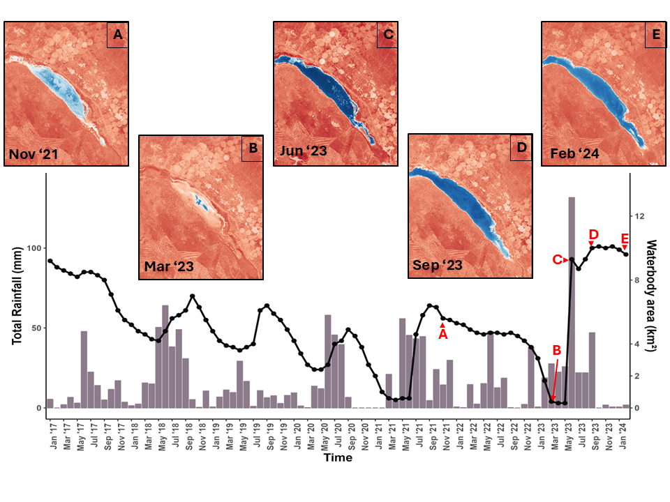
By using the "Water_extent_sentinel_2.ipynb" notebook, Priscah was able to map the spatial extent of water bodies using the Modified Normalised Difference Water Index (MNDWI). This notebook also produces water extent maps for the study area which accurately show changes between specified periods. Additionally, she was able to calculate the waterbody area, revealing the lowest water coverage during the monitoring period, which contributed to the lake's acidification due to the presence of acid sulphate soils. When exposed to air, these soils react with oxygen to release sulphuric acid. Although refilling of the lake has helped to raise the pH to a more neutral level, ongoing reductions in waterbody extent continue to influence acidic conditions within the ecosystem.

Total monthly rainfall (bars) and waterbody extent (line) from January 2017 to February 2024. The letters (A-E) correspond to the MNDWI images for each sampling date.
“Catchment precipitation show clear seasonal patterns (Figure 2), with high rainfall between May and September, peaking in June. During this period, total rainfall ranges from 64 mm to 232 mm. Total rainfall from May to June 2023 was 248 mm, peaking in June (i.e., 131 mm), and significantly increased the water area. The waterbody extent is closely linked to rainfall, increasing during wet periods, and decreasing during dry spells (Figure A2; Supplementary Material). The water area peaked at 6.4 km² in September 2021 but dropped to 5.6 km² by November of the same year. A sharp decline occurred between 2022 and 2023, with the extent falling to 0.4 km² by March 2023 and reaching a low of 0.3 km² by April 2023. Freshwater inflow from June to September raised water levels to up to 10.1 km², causing flooding and breaching in lower reaches. By February 2024, the area had decreased to 9.6 km².”
Priscah’s research doesn’t end there. She has the opportunity to share her findings with stakeholders in the Western Cape Department of Water and Sanitation, with the goal of being able to support policy decisions and risk mitigation strategies where needed.
Going forward, Priscah sees interesting possibilities using Digital Earth Africa for her research, where the utilisation is far quicker where previously she had been more reliant on digitising everything and supporting this with drone footage.
She says, “I would also like to map vegetation in in estuaries; in other words, mapping floating vegetation to see how it moves over time, possibly linking this to rainfall and flooding.” In fact one of the chapters in her thesis includes developing an invasive aquatic vegetation database which she will be sending to the South African National Biodiversity Assessment (NBA) which is the primary tool for monitoring and reporting on the state of biodiversity in South Africa.