Using two critical indicators developed by Digital Earth Africa, an alarming trend of declining vegetative cover has been identified throughout Northern Ghana. The region, which is drier than the southern areas of the country, experiences less rain, with vegetation consisting predominantly of grassland and savannah vegetation - with clusters of drought-resistant trees such as baobabs or acacias, shea trees and neem trees. The lessening of vegetation over time poses serious ecological threats.
This is according to preliminary findings by Abdulai Alhassan, a student pursuing an MSc in Climate Change at the Pan African University of the African Union (PAUWES), which use case is outlined below.
Deforestation, frequent bush burning, and land conversion for agriculture pose significant challenges in the northern regions of Ghana, which are emblematic of many savannah areas worldwide. These issues have far-reaching consequences for the local ecosystem and the global pursuit of sustainable development goals, particularly Sustainable Development Goals (SDG) 15 - Life on Land and SDG 13 - Climate Action.
To address these challenges, the Ghanaian government initiated several intervention projects under the Savannah Accelerated Development Authority (SADA) guidance. SADA was tasked with bridging the development gap between the savannah region and Ghana's more humid southern areas. The agency’s main thrust was to promote sustainable development using the notion of a forested and green north to catalyze climate change reversal and improve livelihoods of the most vulnerable citizens in the area. As part of its mandate, SADA launched tree-planting programs to mitigate deforestation, a key contributor to desertification in the region.
The initial success of these programs was limited, which necessitated a re-evaluation of the discourse on desertification in northern Ghana. This assessment involves an examination of progress over two distinct periods, facilitating an evaluation of the environmental well-being of the five northern regions in Ghana. The insights gained from this analysis hold the potential to guide policymakers in making informed decisions and adjustments, thereby enhancing the effectiveness of future interventions in the region.
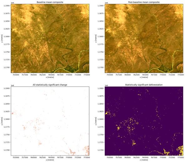
Two critical proxies were used to gain insight into the overall environmental health of the region: the Normalised Difference Vegetative Index (NDVI) and the Enhanced Normalised Difference Impervious Surface Index (ENDISI). These indicators were derived from pre-processed medium-resolution satellite images using pre-developed Python-based packages on the Digital Earth Africa Sandbox.
NDVI: Widely recognised as one of the most valuable vegetation indices, NDVI is considered an excellent proxy for assessing terrestrial vegetation growth and photosynthetic activities. NDVI enabled the assessment of the health and vitality of the region's vegetation, shedding light on changes in vegetative cover over time. What was revealed was a concerning pattern of declining vegetative vitality over the eight-year period. This trend raises significant concerns about deforestation and land-use changes in Northern Ghana, primarily driven by human activities such as settlement expansion. This underscores the urgent need for comprehensive interventions and sustainable conservation efforts through well-balanced land allocation.
ENDISI: A relatively recent indicator tailored to measure urbanisation and impervious surface growth, ENDISI has proven effective in quantifying impervious surfaces across diverse land settings. The incorporation of ENDISI into the analysis aimed to track the expansion of urban areas and assess the impact of land use changes on the environment.
These carefully selected indicators, NDVI and ENDISI, provided a comprehensive framework for evaluating the ecological well-being, urban development dynamics, and land use conflicts within the study area. Their use allowed for a nuanced understanding of environmental changes and their implications for the informed management of urban sprawl and the conservation of savannah ecosystems.
Preliminary findings indicate an alarming trend of declining vegetative cover throughout Northern Ghana. This decline is a clear indicator of deteriorating forest health, as evidenced by the decreasing Normalised Difference Vegetative Index (NDVI) values spanning from 2013 to 2021.
Future Implications and Planned Next Steps
While the data tell a compelling story of declining forest health, it is imperative to delve deeper into the underlying factors driving this phenomenon. The current limited understanding of why this loss of vegetative cover is occurring underscores the need for comprehensive research to unearth the intricate nature of this problem. Several factors may contribute to this issue, including deforestation, land use change, climate change, human activities, policy and governance, and community engagement.
By conducting in-depth research encompassing these aspects and collaborating with local experts and communities, we can work towards finding answers that offer a comprehensive and satisfactory explanation for the loss of vegetative cover in Northern Ghana. This knowledge will be instrumental in devising effective strategies and interventions to address this critical environmental issue.
Conclusion
Generating evidence plays a pivotal role in shaping the narrative for policymakers and duty bearers to take decisive action in the best interest of the environment. Sound research and data-driven insights provide the foundation upon which informed decisions can be made to safeguard our ecological heritage.