“Digital Earth Africa is a ‘weapon of mass creation’ with the ability to place a wand in every hand - from policymaker to young professional - to improve life on earth using satellite remote sensing.”
So says Thando Mathe, a GIS consultant and co-founder of Spatial Sense Inc. a Zimbabwe-based technology start-up. Spatial Sense Inc. uses geospatial technology to improve lives in Africa by supporting sustainable development projects in land resource governance.
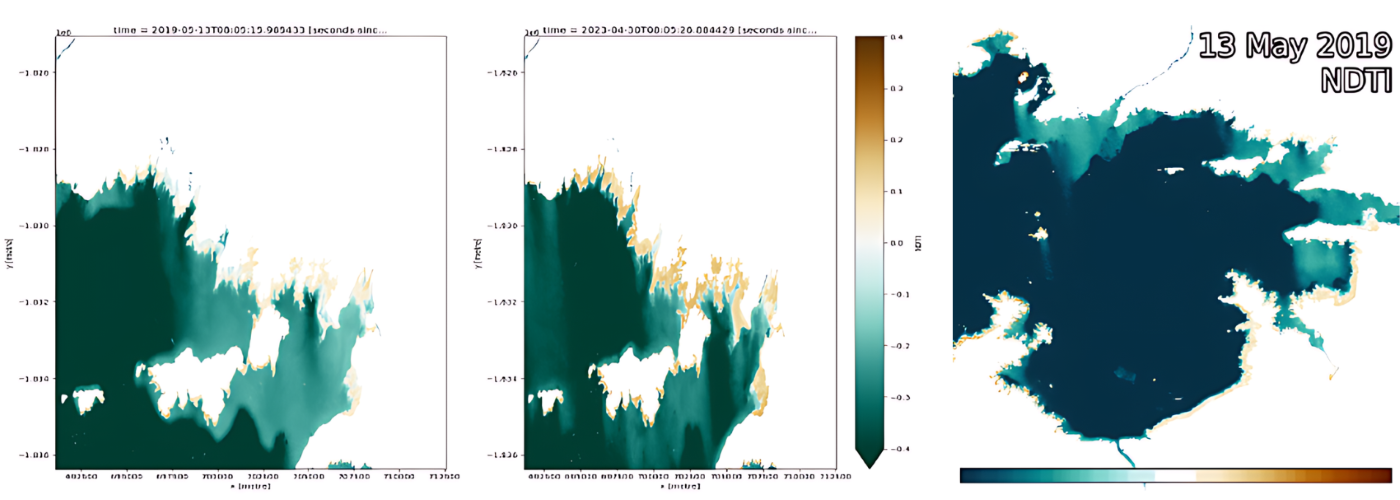
A few months ago, Thando was invited to share his knowledge at the United Nations 6th Conference on Space Technology for Water Management. Thando presented analysis that centred on measuring the water turbidity in Lake Kariba, which is the largest lake in Zimbabwe and second-largest man-made lake in the world. Thando explains that understanding water turbidity is important given that it measures water cloudiness or haziness which is caused by large numbers of individual particles that are generally not observable with the naked eye. The measurement of turbidity is a key test for both water clarity and water quality.
The challenges
Lake Kariba supports key ecosystems and economies in agriculture, power and wildlife for both Zambia and Zimbabwe. Importantly, Lake Kariba is the predominant water body supporting both commercial and small-scale fisheries, which contribute significantly to the economies of the two countries. Yet a declining fish population (among other challenges that include a reduction in water levels) is an ongoing challenge to livelihoods for the surrounding communities. Understanding water turbidity is an important tool in assessing water quality deterioration.
Thando says, “Policymakers struggle to acquire accurate quality data at low cost for evidence-driven decision-making. Furthermore, local authorities lack sufficient infrastructure and skills to process this data. My analysis sought to demonstrate how low-cost and open access cloud platforms for remotely sensed earth observation data can be strategically implemented to support policymaking organisations.”
The science
In undertaking his analysis, Thando delineated a portion of the lake closer to Kariba town. He opted to use the Digital Earth Africa platform due to its efficiency and availability of dedicated tools for data processing, specifically measuring water extent using the Water Observation from Space (WOfS) service to alienate water features, and data accessed from LandSat 8 and 9. Thando also utilised CHIRPS data (this is Climate Hazards Center InfraRed Precipitation with Station data which monitors rainfall). The Normalised Difference Turbidity Index (NDTI) was calculated. This infers turbidity which is simplified as the optical clarity of the water. Lower NDTI means clearer water.
When analysing rainfall, turbidity and water body size, the investigation revealed that in the case of Lake Kariba (in the delineated area) turbidity is not influenced by the size of the water body. However, the CHIRPS rainfall data over the same period indicated that high rainfall seasons coincide with high turbidity seasons. Thando says that this information is useful for decision-making across multiple sectors affected by the lake, including:
- Fisheries, to enable economic and health decisions
- Portable water, to help frame health and sanitation policy
- Tourism, and the impact that water activities and chemical fuels may have on water quality
- Informing public health strategies
- Wildlife sustainability in the surrounding areas.
Thando’s analysis illustrates how turbidity measurements are acquired, compared and visualised without need for massive local compute. He says, “Going forward we are developing conversations to demonstrate and evangelise the use of geospatial technology to potential beneficiaries so as to support policy decisions that underpin social, economic and environmental issues. It’s important to showcase the accessibility of powerful tools to non-technical users, and particularly where they can benefit under-resourced rural and urban municipalities.”
About Thando Mathe
 Thando is from Zimbabwe. As well as being the co-founder of Spatial Sense. Inc, he is also the president at OpenStreetMap Zimbabwe.
Thando has a BSc Hon Geoinformatics and Surveying Engineering. He is a Mandela Washington Fellow ’24.