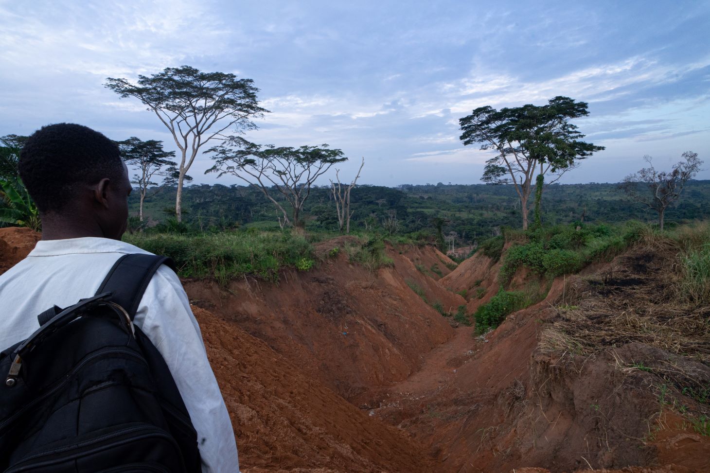
To say that unchecked soil erosion in the Kasai region of the Democratic Republic of Congo (DRC) is a direct threat to livelihoods and food security for local communities is no exaggeration. Thwarted by “mega” erosion and habitual flooding that carves deep gullies and impassable areas into the landscape, villagers are increasingly cut off from Tshikapa, the capital city of Kasai Province and a main trade area. This has a devastating effect on livelihoods and food supply.
Journalist Ruben Nyanguila is taking the matter into his own hands. A young photojournalist and community-led sustainability advocate hailing from Mbuji-Mayi in DRC, Ruben was accepted to take part in the Oxford Climate Journalism Network, which is a six-month training and networking program in climate journalism.
Equipped with a drone and camera, Ruben is currently travelling around villages in the Kasai region to better understand the causal effects of erosion, with plans to document this phenomena and provide locals with a better understanding of what it is that they are having to deal with.
But, says Ruben, a lack of accessible data depicting historic and current trends, hotspots and rates of erosion, coupled with a dearth of government-produced information on the subject, has made understanding and investigating erosion a challenging task.
To assist with his research, Ruben was put in touch with Digital Earth Africa through a mentor from Esri, to whom he was introduced via the Oxford Climate Journalism Network. Digital Earth Africa’s data is available directly through Esri’s highly-subscribed Africa GeoPortal, providing a powerful combination of earth observation data and GIS tools.
Ruben says, “It’s critical for me to have access to satellite imagery and complementary data to help inform my understanding of what is happening on the ground. This resource will directly inform the direction of my investigation.”
Erosion in the Kasai Province is due to a variety of factors. Instances of heavy rain falling on unconsolidated soil (which sandy composition makes it naturally prone to erosion) is compounded by numerous detrimental anthropogenic (human-induced) activities such as bushfires and inadequate agriculture practices.
On a practical level, communities are struggling, explains Ruben. “Right now villagers are cut off from the main city where they both buy and sell agricultural products, making it a challenge to sustain their families.”
Ruben says that there is confusion about erosion, clouded by cultural complexity. “A lack of educational information provided by government and community leaders has resulted in many people, both in the cities and villages, attributing erosion to witchcraft. This means that erosion is regarded as an immutable force against which villagers are powerless to intervene.”
For Ruben, it is important to educate and inform so that communities are empowered to make decisions based on evidence and knowledge at hand. His goal is to ultimately work with local radio stations in the development of a podcast presented in local languages, which will explain the reasons, impacts and potential behavioural changes required to reduce the rates of degradation in erosion-prone areas.
Ruben will be working with scientists from Digital Earth Africa and Esri to access the data that he will need to make his case. This unfolding story, driven by a young journalist with a passion for community-led interventions, is at its early stages. More is yet to come.
Ruben Nyanguila can be contacted via LinkedIn: https://www.linkedin.com/in/ruben-nyanguila-872085258/
For more on Ruben’s work, visit his Instagram profile: https://www.instagram.com/ruben_nyanguila?igsh=YzljYTk1ODg3Zg==
Image depicts erosion and road infrastructure in Kasai Region, DRC. Image supplied by Ruben Nyanguila