Ghana’s coastline is undergoing rapid transformation due to coastal erosion, impacting local communities, ecosystems, and economic activities. To better understand and address these changes, researchers are leveraging satellite data and geospatial tools to monitor shoreline shifts and develop solutions.
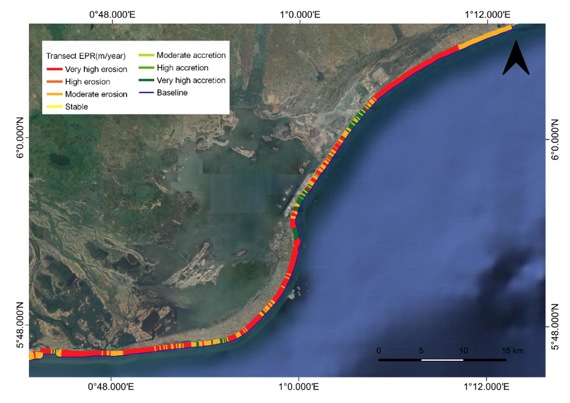
Mr. Patrick Nii Lante Lamptey, a doctorate student at Akenten Appiah Menka University of Skills Training and Entrepreneurial Development, is leading a research initiative on behalf of Ghana’s Space Science and Technology Institute (GSSTI). The objective is to assess the feasibility of using DE Africa’s Coastline Monitoring Service to track and mitigate erosion at Keta Lagoon and Cape Coast.
The real-life cost of erosion
Ghana’s eastern and central coasts face significant erosion. This has led to widespread livelihood loss, environmental degradation, and health challenges.
Fishing communities have been particularly affected as the silting of the Keta Lagoon and destruction of mangroves disrupt their activities, while crop farming has suffered due to land degradation. Tourism, another critical industry, is also under threat as receding shorelines on the Cape Coast, along with frequent tidal waves damage infrastructure and natural attractions.
The environmental consequences are equally severe, with habitat loss, biodiversity destruction, and increased vulnerability to climate change.
Additionally, coastal erosion has triggered serious health concerns, with saltwater intrusion affecting groundwater quality, leading to sanitation and hygiene issues in affected communities.
These effects bear a very real cost for those communities living on the coastline and around the Keta lagoon, where they must balance hard choices between upheaval or displacement, against potential health problems, dwindling livelihoods and incessant food insecurity.
To mitigate these impacts, Mr. Lamptey’s research focuses on identifying erosion hotspots and assessing the effectiveness of existing sea defence mechanisms, such as groins—perpendicular structures designed to trap sand and reduce erosion—revetments, which are sloped barriers that absorb wave energy, and beach nourishment, the process of adding sand to restore eroded shorelines. These measures have been implemented by the Ghanaian government since 1999.
Leveraging Digital Earth Africa’s Tools for Coastal Monitoring
The large-scale nature of coastal erosion necessitates historical satellite datasets and high-performance computing for analysis. DE Africa’s services, built on the Open Data Cube, along with the sandbox environment, have been instrumental in processing and visualising vast amounts of satellite imagery efficiently. These tools have allowed Mr Lamptey and researchers to map shoreline position changes over time, identify erosion and accretion zones, assess the effectiveness of sea defence structures, and develop an early warning system for coastal communities. Additionally, the research team, which includes experts from academia, planning, industry, and policy advocacy, integrates QGIS software for local data processing and visualization to complement DE Africa’s tools.
Developing crucial tools for government agencies
Through satellite-based shoreline mapping, the research has revealed critical insights into the dynamics of coastal erosion in Ghana. The study has successfully identified high-risk erosion zones and evaluated the impact of existing sea defence projects, providing valuable data to support future interventions. These findings will contribute to the development of a near real-time coastal erosion monitoring system, which will serve as a crucial tool for government agencies such as the National Disaster Management Organisation, Fisheries Commission, Ghana Navy, and the Ministries of Environment, Science, Technology, and Innovation, as well as Works and Housing.
Additionally, policy and planning bodies will integrate these insights into Ghana’s Marine Spatial Plan and Integrated Coastal Zone Management policy. Non-governmental organizations (NGOs) working on mangrove restoration and marine conservation will also benefit from this monitoring system, enabling more targeted and effective conservation efforts.
Protecting Ghana’s Coastal Communities
A key future impact of this research is the development of a shoreline monitoring application that provides early warnings for potential erosion threats. This tool will enable decision-makers to implement timely interventions, protect coastal ecosystems, and ensure the resilience of vulnerable communities. For Mr Lamptey, DE Africa’s tools have revolutionized how coastal erosion is studied in Ghana by providing cost-effective and efficient satellite data processing, allowing researchers to focus on insights and solutions rather than spending extensive time on data handling.
As Ghana continues to combat coastal erosion, satellite technology and geospatial analysis will play a crucial role in safeguarding both livelihoods and the environment.
About Mr Nii Lante Lamptey
Mr. Patrick Nii Lante Lamptey is a doctorate student in Environmental Health and Sanitation Education at Akenten Appiah Menka University of Skills Training and Entrepreneurial Development. With a background in Remote Sensing and GIS in Water Resources Management, he is passionate about leveraging geospatial tools for environmental sustainability.