 اللغة الإنجليزية
  البرتغالية
  الفرنسية
  العربية
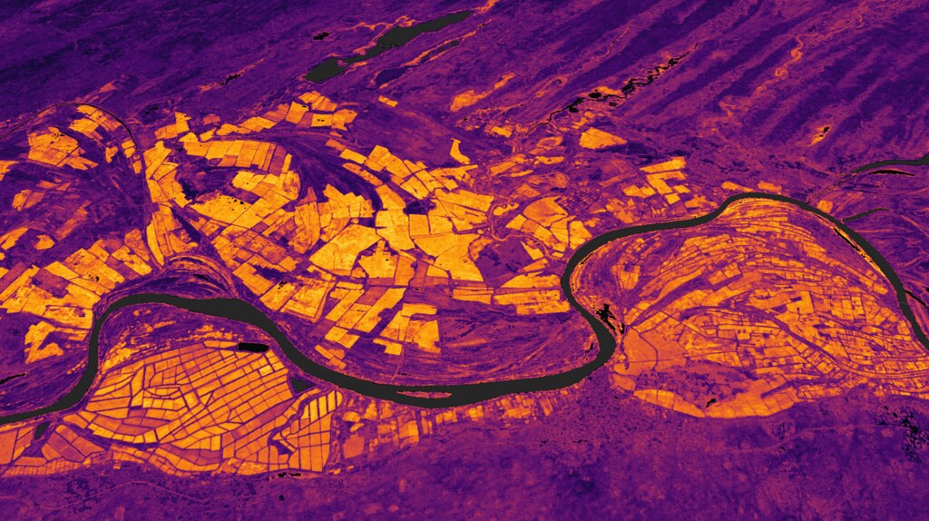
في جميع أنحاء أفريقيا، يتخذ المزارعون قرارات يومية تعتمد على التوقيت: متى يجب أن نزرع؟ ما هو أفضل وقت لتطبيق السماد؟ هل المحصول يتقدم بشكل جيد؟ هل الأمطار الأخيرة أحدثت فرقًا؟ تقليديًا، تعتمد هذه الإجابات على الخبرة والملاحظة. ولكن في مناخ متغير، حيث يمكن أن يتغير هطول الأمطار وتضرب الآفات بصمت، يحتاج المزارعون إلى إشارات أسرع وأوضح، يفضل أن تكون قبل أن يصبح الإجهاد مرئيًا على أرض الواقع.
تعمل منظمة "الأرض الرقمية أفريقيا" (Digital Earth Africa - DE Africa) مع شركاء في القطاع الزراعي لجعل ذلك ممكنًا.
في مقاطعة ناكورو، كينيا، استكشف تعاون ضم معهد تغذية النبات الأفريقي (APNI) والدكتور نورم كامبل (كبير علماء الأبحاث/إحصائي سابق في CSIRO)، و OCP Africa، ومزرعة معهد ريفت فالي للتكنولوجيا (RVIST) كيف يمكن لصور الأقمار الصناعية دعم مراقبة المحاصيل عبر مواسم النمو الرئيسية. باستخدام بيانات Sentinel-2 (دقة 10 أمتار) و PlanetScope (دقة 3 أمتار)، ركزت المبادرة على تتبع التطور الموسمي لحقول الذرة والقمح من خلال التوقيعات الطيفية، وهي “الاستجابة الضوئية” الفريدة التي تبعثها النباتات أثناء نموها.
تتيح المنصة المفتوحة لـ DE Africa لأصحاب المصلحة الوصول إلى بيانات الأقمار الصناعية الجاهزة لاتخاذ القرار مثل صور الانعكاس السطحي، ومؤشر الغطاء النباتي الطبيعي (NDVI)، والغطاء المجزأ، كل ذلك دون الحاجة إلى تنزيل ملفات خام أو معالجتها. بدلاً من خطوط أنابيب النمذجة المعقدة، يمكن للمستخدمين التفاعل مع أدوات قائمة على الخرائط توفر عرضًا بسيطًا لخضرة المحاصيل، وثبات الغطاء النباتي، أو تعرض الأرض بمرور الوقت.
من خلال دمج المعرفة الميدانية من موظفي RVIST مع تسلسلات الصور الطيفية التي أعدها APNI والدكتور كامبل، يوضح التعاون كيف يمكن دمج المشاهدات الأرضية والرؤى من الأقمار الصناعية لتوفير فهم أفضل لتطور المحاصيل. وبينما تظل البيانات الميدانية سرية وتستمر المنظمات المشاركة في تقييمها، فإن العملية نفسها تسلط الضوء على تحول مهم: لم يعد رصد الأرض محصورًا بالوكالات الوطنية والمختبرات البحثية. بل أصبح أداة يمكن للمزارعين وخبراء الزراعة والمؤسسات التدريبية التعامل معها مباشرة.
مع تقدم هذا العمل، ستواصل DE Africa دعم المنظمات الأفريقية لفهم ما تعنيه الأنماط الطيفية المختلفة في سياقات زراعية حقيقية، مما يساعد على تحويل البكسلات الخام إلى رؤى عملية. سواء كان ذلك يتعلق بتحديد النافذة المثلى للزراعة، أو مقارنة تقدم المحاصيل عبر الحقول، أو فهم كيف يشكل الطقس التنمية، فإن المراقبة القائمة على الأقمار الصناعية تفتح جبهة جديدة للزراعة الأفريقية.
مستقبل الزراعة ليس في التربة فحسب، بل في السماء أيضاً. وباستخدام الشراكات الصحيحة، تضع أفريقيا نفسها في وضع يسمح لها بقراءة كليهما.