 اللغة الإنجليزية
  البرتغالية
  الفرنسية
  العربية
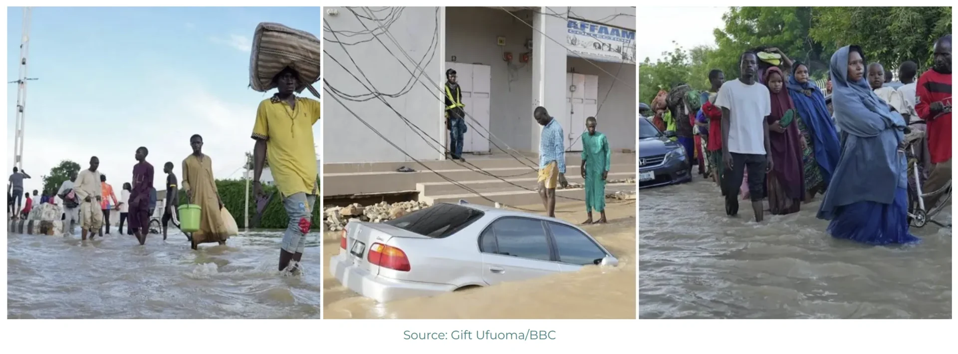
Kenya has experienced a dramatic shift from a prolonged, severe drought, to catastrophic flooding. In 2024, intense rainfall resulted in flooding across the country, claiming the lives of at least 228 people and displacing over 212,000 others in May. While the country typically anticipates heavy rainfall during the long rainy season from March to May, the scale of these events was unprecedented. During the 2025 rainy season currently underway, heavy rainfall has caused rivers to overflow, particularly in Isiolo and Baringo counties, displacing families and damaging infrastructure. Flash floods were reported in urban areas which exacerbated a cholera outbreak.
The situation again highlights the need for robust forecasting and better preparation, says Dr Lisa Rebelo, Acting Managing Director and Lead Scientist at Digital Earth Africa. “Analysis-ready earth observation (EO) data derived from satellites presents significant opportunities for governments to convert this readily available information into actionable forecasting, protection- and recovery strategies that can save lives and sustain livelihoods.”
However, Rebelo emphasises that while extensive data exists, the essence of effective disaster response and resilience lies in how this information is accessed to guide decision-making and policy development in both the immediate and long-term contexts.
“During disasters, the International Charter Space and Major Disasters is activated, providing earth observation data to enable swift on-the-ground response. The question is after the disaster has passed, how should governments respond over the longer term; and how can they build the resilience of those communities to ensure it doesn’t happen again,” says Rebelo. ”Detailed analysis of where floods have happened enables better forecasting. Digital Earth DEA’s data can be ingested into data tools and aid the response over the longer term, providing context to guide governments to take the necessary actions.”
By packaging EO data into accessible and open data sets and building knowledge and capacity, Digital Earth Africa makes it possible for African governments, industry players and decision-makers to track changes across the continent in unprecedented detail, says Rebelo. “This can inform governance and policy decisions around managing water systems, inform assessment of insurance risk as well as assessing the health of a water body or system. Ultimately, it enables better decision making across areas that include flooding, drought, soil and coastal erosion, agriculture, forest cover, land use and land cover change, water availability and quality, and changes to human settlements.”
Users can take advantage of Africa Geoportal, an open geospatial mapping software platform developed by Esri, a Digital Earth Africa partner, to analyze their data in geographic context. “Geospatial technology is critical in supporting informed decision-making and sustainable development across Africa,” explains Lorien Innes, Africa Geoportal Manager and Senior Business Development Manager at ESRI. “Digital Earth Africa’s tools, including the Water Observations from Space service are already accessible via Africa Geoportal. Furthermore, the complete dataset for the Continental Waterbodies Monitoring Service will soon be integrated, providing users with additional data to monitor floods and gain insights into affected areas and households.”
The Continental Waterbodies Monitoring Service is one of several analysis-ready products available in the Digital Earth Africa platform. A world first due to the innovative science behind the product, it allows for better understanding and monitoring of water availability anywhere in Africa. Updated weekly, it has captured 40 years of Earth observation statistics of 700,000 unique waterbodies across the continent. It allows African countries to map, assess and visualise surface water and understand water availability trends over time, including the impacts of floods and droughts.
As global temperatures rise, East Africa may see an overall decrease in rainfall volume; however, the frequency and intensity of extreme rainfall events are projected to rise, as a warmer atmosphere can hold more moisture, making dramatic floods more likely. By analysing the data, it becomes evident which communities would be vulnerable in the event of flooding. When people are still coping with the aftermath of one extreme weather event, they are very vulnerable to others.
Leveraging satellite imagery and data tools for flood analysis in Garissa
An example of how EO data can be used during flooding events was evident during the flooding that took place in Garissa, the capital of Garissa County, situated in the North-Eastern Province of Kenya in 2024. The data indicates that although there has been urban expansion away from the floodplain, communities have existed near flood-prone areas since the 1980s. It is crucial to establish flood defences and put risk management strategies in place to protect these communities and agricultural lands moving forward.
Analysing flood impacts with Sentinel-2 data
Sentinel-2 satellite imagery, enhanced with Short-Wave Infrared rendering, reveals the extent of the April 2024 floods with exceptional clarity. The imagery displays flooded areas in shades of blue, offering real-time information on the scale of inundation. By stepping through dates incrementally, analysts document changes in water levels from April to May, creating a dynamic timeline of the flooding. This data supports accurate damage assessments and guides immediate relief efforts for affected areas.
Integrating localised data for a holistic view
Complementing the satellite imagery, the Garissa County Flood Watch dashboard available via ArcGIS provides a detailed look into the socio-economic impact of the floods. The dashboard includes metrics on households affected and the status of critical facilities like schools and hospitals. This granular data offers a comprehensive understanding of the broader community implications. It also estimates costs for temporary shelters and long-term reconstruction, enabling local authorities to prioritise budgeting and secure funding for recovery.
Visualisation tools within the dashboard allow stakeholders to focus on high-impact zones in Garissa Town. By toggling between flood severity and response category layers, planners map out strategies for areas classified as critical, major, moderate or minorly impacted. This localised perspective enhances prioritization of resource deployment and minimises additional disruptions.
Proactive flood forecasting with GEOGLOWS data
Anticipating future floods helps communities remain resilient in the face of potential disasters. The Africa Streamflow Forecast Viewer provides a forward-looking perspective by using GEOGLOWS data to generate 10-day streamflow forecasts. For Garissa, current predictions at the time of writing indicate a 10 cm increase in stream flow, remaining below the 2-year return period threshold. This ten-day forecast gives authorities critical lead time to prepare for a flood event, and reduces the risk of loss of lives and livelihoods.
The viewer’s ability to display return periods offers insights into the likelihood of floods reaching critical levels. This forecasting capability strengthens early warning systems, empowering communities to take proactive measures before disasters strike.
Combining satellite data with localised dashboards demonstrates the power of Digital Earth Africa’s services and ESRI’s geospatial tools. Together, these technologies enable African nations to address environmental challenges with precision and efficiency. With these platforms, resource management becomes more data-driven, and emergency responses are prompt and well-informed.
“Access to geographic insights is everything,” says Olivier Cottray, Director of Humanitarian and Sustainable Solutions at Esri. “From developing land use plans to providing situational awareness on the ground, and sharing up to date information with response organisations to help prioritize efforts, geospatial data and tools are critical when literally every minute counts”
For Garissa County and beyond, the integration of satellite imagery, forecast models, and interactive dashboards represents a new era of disaster preparedness and resilience. The wealth of data provided by Digital Earth Africa’s services like the Waterbodies Continental Service and Water Observations from Space (WOfS), among a host of other products, can significantly enhance water management strategies across Africa.
The WMO report ‘State of the Climate for Africa – 2024’ calls for early warning for all. “We have the data to equip governments to ensure that early warning for all is being addressed,” says Rebelo. “Accurate and consistent data will help address Africa’s development challenges. Governments can act decisively in implementing these systems, ensuring that they are equipped with the knowledge needed to prepare for and respond to climate-related risks effectively.”
Links to resources: