 اللغة الإنجليزية
  البرتغالية
  الفرنسية
  العربية
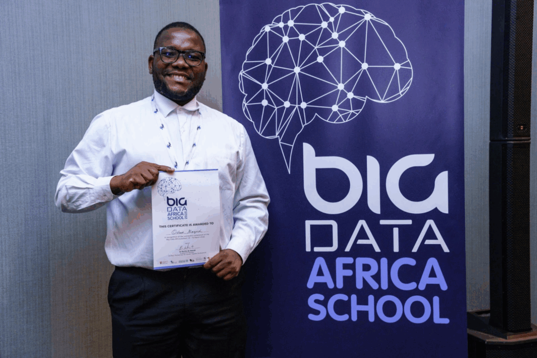
Osbone Antonio Maquival is a mathematician from Mozambique whose journey into Earth Observation began at the Big Data Africa School. There, he was introduced to Digital Earth Africa’s tools, which opened the door to using satellite data for real-world challenges. That foundation propelled him to the Africa Climate Summit in Addis Ababa, where he showcased how DE Africa supports climate action and continues to inspire his current work in flood mapping and environmental monitoring. In this spotlight, he shares how his academic background in mathematics and statistics blends with EO tools to drive impactful solutions for Africa.
أخبرنا قليلاً عن نفسك. ما هي خلفيتك الأكاديمية، وما الذي أثار اهتمامك بمجال رصد الأرض أو المجال الذي تعمل فيه حالياً؟
I have a degree in Mathematics and Statistics from Licungo University in Mozambique. I also completed a Master’s in Mathematical Sciences at the African Institute for Mathematical Sciences (AIMS). My focus is on mathematical modeling, especially for tropical diseases like malaria, and on using Earth Observation (EO) data to study climate change, public health, and the environment.
كيف اكتشفت ديجيتال إيرث أفريقيا، وما الذي جذبك إلى أدواتها؟
I first learned about Digital Earth Africa during the Big Data Africa School. We were trained to use DE Africa tools, and from that moment I started my journey on the platform. What attracted me most was the open access to powerful satellite data and tools, which help young African researchers like me work on real problems with limited resources.
ما هو تركيز بحثك أو مشروعك الحالي، وكيف تساعد بيانات الاستشعار عن بعد (EO)؟
Right now, I am working on a project called Flood Extent Mapping. I use DE Africa tools and data to create a Deep Learning model for mapping floods. The platform helps because of its strong computing power and free access to data. I also use DE Africa for other tasks, like monitoring conservation areas. During my internship in a national park, DE Africa supported me with analysis to better understand the environment and support decision-making.
ما هي مجموعات بيانات أو دفاتر الملاحظات الخاصة ب DE Africa المحددة التي استخدمتها في تحليلك؟
The most useful dataset for me is WOFS (Water Observations from Space), because it is perfect for flood and water studies. But I also explore many other datasets. I usually start with Africa Maps, which is simple to use, and then move to the Sandbox, where I can do advanced analysis. Sometimes I watch tutorials on YouTube to learn how to interpret the data and use the tools better.
يمكنك مشاركة إنجاز واحد أو بصيرة واحدة ساعدت DE Africa في تحقيقها؟
One big achievement was being selected as a Young Climate Action Innovation Hub at the Africa Climate Summit in Addis Ababa. There I showed how DE Africa tools help us build solutions for climate change and make Africa more resilient. I also joined the International Camp for Young Builders, Architects, and Designers in the group City as Code: Programmable Urbanism. My experience with DE Africa gave me the skills to contribute to that project on urban development.
هل تعاونت مع آخرين عبر DE Africa؟ كيف أثر ذلك على عملك؟
Yes. I worked with colleagues I met at the Big Data Africa School, from South Africa, Ghana, Madagascar, Namibia, and Zambia. I also collaborated directly with the DE Africa team, for example by presenting the Africa Earth Observation Challenge 2025 (#AEOC2025) in Portuguese. These collaborations helped me learn new methods and build connections with people across Africa and beyond.
يتمثل التحدي الأكبر الذي أراه أمام تبني الاستشعار عن بعد في الأبحاث الأفريقية في عدم كفاية البنية التحتية للمعالجة والتحليل، فضلاً عن نقص البيانات عالية الجودة والمحددة محليًا. غالبًا ما تكون محطات المعالجة باهظة الثمن وتتطلب خبرة متخصصة، مما يجعلها غير متاحة للعديد من المؤسسات البحثية الأفريقية. بالإضافة إلى ذلك، قد تكون البيانات المتاحة عالمياً غير مناسبة في بعض الأحيان للتطبيقات المحلية بسبب الاختلافات في أنظمة النطاقات، ودرجة الدقة، ووقت الحصول على البيانات، أو بسبب عدم توفر بيانات مرجعية أرضية كافية.
للتغلب على هذه التحديات، أقترح ما يلي:
1. **بناء القدرات وتنمية المهارات:**
* **ورش عمل ودورات تدريبية:** تنظيم ورش عمل ودورات تدريبية منتظمة حول تقنيات الاستشعار عن بعد ومعالجتها في جامعات ومراكز أبحاث أفريقية.
* **برامج التبادل:** إنشاء برامج تبادل للباحثين الأفارقة للتدريب في مراكز متقدمة عالمياً في مجال الاستشعار عن بعد.
2. **تعزيز البنية التحتية:**
* **مراكز بيانات محلية:** إنشاء مراكز بيانات إقليمية أو وطنية لمعالجة وتخزين بيانات الاستشعار عن بعد، مع التركيز على استخدام تقنيات الحوسبة السحابية لتقليل التكاليف.
* **مبادرات الوصول المفتوح:** تشجيع الشراكات مع وكالات الفضاء العالمية والشركات الخاصة لتعزيز الوصول المفتوح إلى بيانات الاستشعار عن بعد عالية الجودة.
3. **تطوير البيانات المحلية:**
* **حملات ميدانية:** دمج حملات ميدانية لجمع بيانات مرجعية أرضية دقيقة ومحددة محلياً، والتي تعتبر حاسمة لتصحيح وتفسير بيانات الاستشعار عن بعد.
* **بيانات منخفضة التكلفة:** استكشاف استخدام مصادر بيانات منخفضة التكلفة أو مجانية، مثل الأقمار الصناعية الصغيرة، أو حتى دمج بيانات الطائرات بدون طيار، لزيادة توافر البيانات.
4. **تعزيز التعاون والشراكات:**
* **التعاون الإقليمي:** تشجيع التعاون بين الدول الأفريقية لتقاسم الموارد والخبرات في مجال الاستشعار عن بعد.
* **شراكات مع القطاع الخاص:** إقامة شراكات مع الشركات التي تمتلك إمكانيات في مجال الاستشعار عن بعد لتطوير حلول مخصصة للتحديات الأفريقية.
* **منصات التعاون:** تطوير منصات عبر الإنترنت لتسهيل التعاون وتبادل المعرفة بين الباحثين الأفارقة.
5. **التمويل والاستدامة:**
* **منح مخصصة:** البحث عن منح وتمويل مخصص لدعم مشاريع الاستشعار عن بعد في أفريقيا.
* **الاستدامة المالية:** تطوير نماذج مستدامة مالياً لمراكز معالجة البيانات وصيانتها.
من خلال معالجة هذه القضايا بشكل منهجي، يمكن تعزيز تبني الاستشعار عن بعد بشكل كبير في الأبحاث الأفريقية، مما يتيح قدرات تحليلية أقوى لمعالجة التحديات المتنوعة التي تواجه القارة.
The biggest challenge is the language barrier. Many resources and trainings are only in English, which makes it hard for researchers in Portuguese-speaking countries like Mozambique and Angola. To solve this, DE Africa should expand training and materials in Portuguese. This would help more African communities use the platform and remove barriers in learning.
ما الذي تودون أن تحققه DE Africa بعد ذلك للباحثين في جميع أنحاء القارة؟
I hope DE Africa can reach more Portuguese-speaking countries and organize trainings in local languages. This would allow researchers from all regions of Africa to benefit from the tools and use EO data for local problems.
نصيحة واحدة لباحث شاب يريد استخدام أدوات DE Africa؟
My advice is: just start exploring. DE Africa is open and free for everyone. Do not be afraid to try, make mistakes, and learn. Use the tutorials, ask questions, and connect with the community. Also, always try to connect the data with real problems in your country, like floods, agriculture, conservation, or climate change. This will make your work more useful for society. If you stay curious and consistent, you can grow step by step, and one day you may lead big projects that make a difference in Africa.