 اللغة الإنجليزية
  البرتغالية
  الفرنسية
  العربية
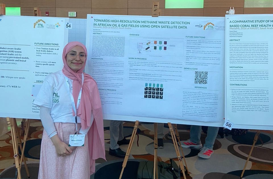
Assala Benmalek is a research engineer based in Algeria with a Master’s degree in Computer Engineering. As part of Africa Space Works, the first space-focused company in Algeria, her research focuses on leveraging artificial intelligence to advance Earth observation applications, with a strong emphasis on detecting greenhouse gas emissions using high-resolution satellite imagery.
Through her work with Digital Earth Africa, she has contributed to building one of the first methane detection datasets for Africa. Using satellite data, her research identifies and monitors super-emission events across key industrial regions, demonstrating how open Earth observation data can support environmental monitoring and AI-driven innovation on the continent.
Briefly describe your academic background and current research focus
I am a research engineer based in Algeria with a Master’s degree in Computer Engineering. As part of Africa Space Works, the first space-focused company in Algeria, my research focuses on leveraging artificial intelligence to advance Earth observation applications, with a particular emphasis on detecting greenhouse gas (GHG) emissions using high-resolution satellite imagery.
How did you first discover Digital Earth Africa, and what made you start using the platform?
I first discovered Digital Earth Africa while helping organise the 5th Big Data Africa School. Later, Dr. Bonita mentioned the platform again during a discussion, and Dr. Sabrina Amrouche introduced me directly to members of the DE Africa team.
I also met one of the team members during the Deep Learning Indaba 2025 conference at the University of Kigali. The Digital Earth Africa team has always been welcoming and supportive, which made engagement with the platform much easier and more meaningful.
What is your current research or project about, and what problem are you trying to address?
My current project focuses on methane monitoring from oil and gas super-emitters across Africa. We aim to detect and track methane emissions using satellite data to enable early identification of emission events and support mitigation efforts.
As part of this work, I initiated a data collection effort to build one of the first methane detection datasets for Africa, in collaboration with Digital Earth Africa. This dataset will help improve AI models for methane plume detection and environmental monitoring.
How does Earth observation data support this work, particularly Sentinel-2 imagery?
This project focuses on detecting critical methane hotspots and emissions from major oil and gas super-emitters across Africa. I began with Algeria, which is a priority in my current role, concentrating on emission hotspots in Hassi Messaoud and Hassi R’Mel.
Earth observation data plays a central role in this effort. In particular, Sentinel-2 imagery supports methane monitoring through its Short-Wave Infrared (SWIR) bands, which are sensitive to methane absorption features. These spectral characteristics enable the detection and analysis of methane plumes using high-resolution satellite data.
Which Digital Earth Africa tools or datasets have been most useful to you, and how do you use them in practice?
Digital Earth Africa has been instrumental in advancing my research. I have benefited from its training courses and primarily use the Sandbox, which provides efficient and faster access to data for analysis. My work has focused mainly on the Sentinel-2 imagery dataset.
The DE Africa documentation has also been a valuable resource for understanding available satellite products and identifying features relevant to methane detection and environmental monitoring.
Can you share one key insight or outcome from your work using Digital Earth Africa?
Using Digital Earth Africa, we successfully detected active super-emitters previously reported in literature in Hassi Messaoud, Algeria. One significant methane emission event identified in our analysis occurred in 2019 and persisted for approximately 11 months.
Building on these results, we are developing one of the first methane detection datasets for Africa. This dataset aims to improve computer vision models for methane plume detection and support AI-driven monitoring solutions across the continent.
Have you collaborated with other researchers or institutions through this work?
Not directly through this specific project, but engagement with the Digital Earth Africa community has expanded my research network. Through the exposure and support gained from DE Africa, I recently joined the GeoHealth research group at NASA to deepen my understanding of Earth observation applications for air quality monitoring.
This collaboration has broadened my perspective on how satellite data can address environmental and public health challenges and is shaping the future direction of my research.
I have also presented this work at the Deep Learning Indaba at the University of Rwanda and at King Abdullah University of Science and Technology (KAUST), sharing insights on methane monitoring in Africa using satellite data.
From your experience, what is the biggest barrier to wider EO adoption in African research, and what would help overcome it?
One of the biggest barriers is the limited availability of open, well-curated datasets tailored to local African challenges. In my work, I encountered this difficulty while searching for methane detection datasets relevant to the continent.
This gap motivated me to connect with Digital Earth Africa experts for guidance and collaboration. Expanding access to open datasets, technical training, and community support would significantly accelerate Earth observation adoption across Africa.
What would you like to see Digital Earth Africa prioritise next for researchers across the continent?
Air quality monitoring is a critical and timely priority for Africa. I would like to see Digital Earth Africa expand its datasets and tools to better support research and applications focused on air quality and atmospheric emissions across the continent.
What advice would you give to a young researcher interested in using Digital Earth Africa tools?
I recommend starting with the Digital Earth Africa training courses and documentation, as they provide a strong foundation for working effectively with Earth observation data. Practising with the GitHub repositories and experimenting in the Sandbox are also excellent ways to gain hands-on experience.
The platform makes open data accessible and usable and I truly appreciate its efforts to support African researchers.