 Anglais
  Português
  Français
  العربية
 Nigeria is increasingly using space-based and geospatial technologies to respond to challenges in agriculture, water resources, rapid urbanisation, and environmental change. To further support this agenda, Digital Earth Africa (DE Africa) and the National Space Research and Development Agency (NASRDA) organised a series of capacity building workshops on the use of DE Africa platforms from 3 to 7 November 2025.
The training brought together staff from NASRDA and its affiliated centres to build practical skills in accessing, analysing, and applying Earth observation data using DE Africa’s suite of open-access platforms. The series supported NASRDA’s broader mission to grow national expertise in space science and technology for sustainable development.
Introducing DE Africa tools for decision-making
The programme opened with an introduction to Digital Earth Africa platforms. The session provided an overview of how DE Africa utilises freely available Earth observation data in an analysis-ready format, combined with cloud computing infrastructure, to support climate change and food security initiatives across the African continent.
Participants were introduced to key DE Africa products, including GEOMADs, Water Observations from Space (WOfS), and the Coastlines Monitoring service. Facilitators highlighted their use in applications such as water resource management, crop monitoring, coastal erosion assessment, and land degradation mapping. By the end of the day, participants had a clearer view of how DE Africa’s services can support operational decision-making across multiple sectors.
Applying Earth observation to agriculture and food security
Agriculture was a major focus of the week. Using DE Africa Maps and the DE Africa Sandbox, participants familiarised themselves with products such as crop extent and functional cover.
Through hands-on practice, they explored notebooks for analysing crop health, vegetation greenness, and phenology, using both optical data and Sentinel-1 radar sensors. This practical work demonstrated how Earth observation can inform crop monitoring and support planning and interventions in the agricultural sector, particularly in the context of changing climatic conditions.
Monitoring water resources, floods, and wetlands
The session on water resources highlighted tools for mapping water bodies, analysing long-term water extent, and understanding flooding. Using DE Africa Maps and the Sandbox, participants worked with products such as WOfS and the Waterbodies service, which are used to monitor surface water, analyse historical trends, and identify flooded areas.
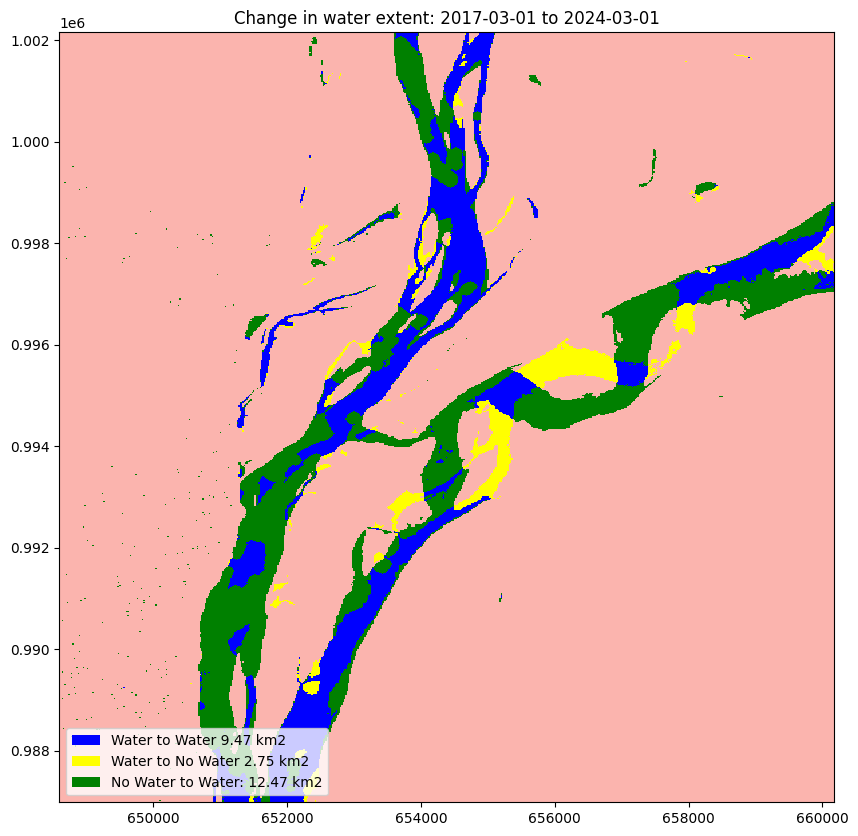
Sentinel-2 datasets were used to understand seasonal water trends, while additional approaches were introduced to assess wetlands through the Wetland Insight Tool, and water quality through indicators like chlorophyll content and Total Suspended Matter. A specific example focused on flooding along the Lokoja River in Nigeria, comparing conditions in 2017 and 2024, and showcasing how these tools can support risk assessment and disaster preparedness.
Understanding urban expansion and coastal erosion
Another key theme of the training was monitoring Nigeria’s rapidly changing urban and coastal environments. The session focused on tracking urban expansion and coastal change using free data, particularly the DE Africa Coastlines service accessed through Maps and the Sandbox.
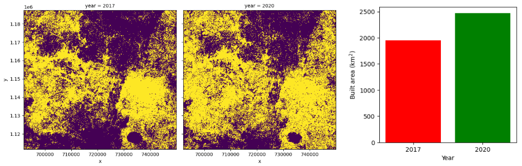
Participants explored urban change detection in Lagos and Ibadan, using proxies such as the Enhanced Normalized Difference Impervious Surfaces Index (ENDISI). The team also analysed urbanisation trends in Abuja, combining the Global Human Settlement Footprint with Sentinel-1 radar data. The analysis showed that between 2017 and 2020, Abuja’s urban area expanded from 1,946 km² to 2,468 km². The session further covered the coastal erosion tool, monitoring shoreline changes in areas such as Lekki and highlighting how DE Africa products can support coastal management and planning.
From training to operational use cases
The final day focused on developing use cases to translate new skills into tangible applications. Participants were guided on submitting use cases to DE Africa through a dedicated form, clearly outlining objectives, study areas, time frames, and expected results. This process was highlighted as a critical pathway for achieving on-the-ground impact, with participants encouraged to submit individual or group requests. The DE Africa technical team can address each request separately or group similar use cases for coordinated support, ensuring that training outcomes translate into practical applications aligned with institutional priorities.
During the closing remarks, Aderoju Laide, Head of Environment and Climate Change in NASRDA’s Strategic Space Applications (SSA) Department, praised the successful week and encouraged staff to maximize the use of DE Africa platforms, noting the potential to generate published papers and develop “bankable proposals” in the near future.
The workshop series marked an important step in strengthening Nigeria’s capacity to use geospatial technologies and Earth observation data for sustainable development. Participants concluded the training with practical skills in accessing and applying DE Africa products to agriculture, water resources, urban growth, coastal erosion monitoring, and broader SDG-related priorities, including AI and ML for evidence-based decision-making.
Through this collaboration, Digital Earth Africa and NASRDA are helping ensure that satellite data are transformed into actionable insights that support policy, research, and investment, contributing to improved quality of life and long-term socio-economic development in Nigeria