 English
  Português
  Français
  العربية
In a significant step toward enhancing climate-resilient agricultural practices, Umuryango wo Gushyigikira AMAkoperative (UGAMA), a Rwandan non-governmental organization, has announced plans to adopt Earth Observation (EO) technology to support its agricultural projects. With a longstanding history of improving cooperative leadership, sustainability, and profitability since its inception in 1984, UGAMA seeks to integrate geospatial technologies to enhance decision-making and resource management.
The Shift from Traditional Data Collection to EO
Historically, UGAMA has relied on in situ data for planning, monitoring, and evaluation—a process that demands extensive time and resources. However, the organization now aims to transition to free and open-source geospatial platforms like Digital Earth Africa (DE Africa). Despite limited technical expertise among personnel, UGAMA is determined to build internal capacity and leverage EO data for better agricultural planning.
Capacity Building with DE Africa
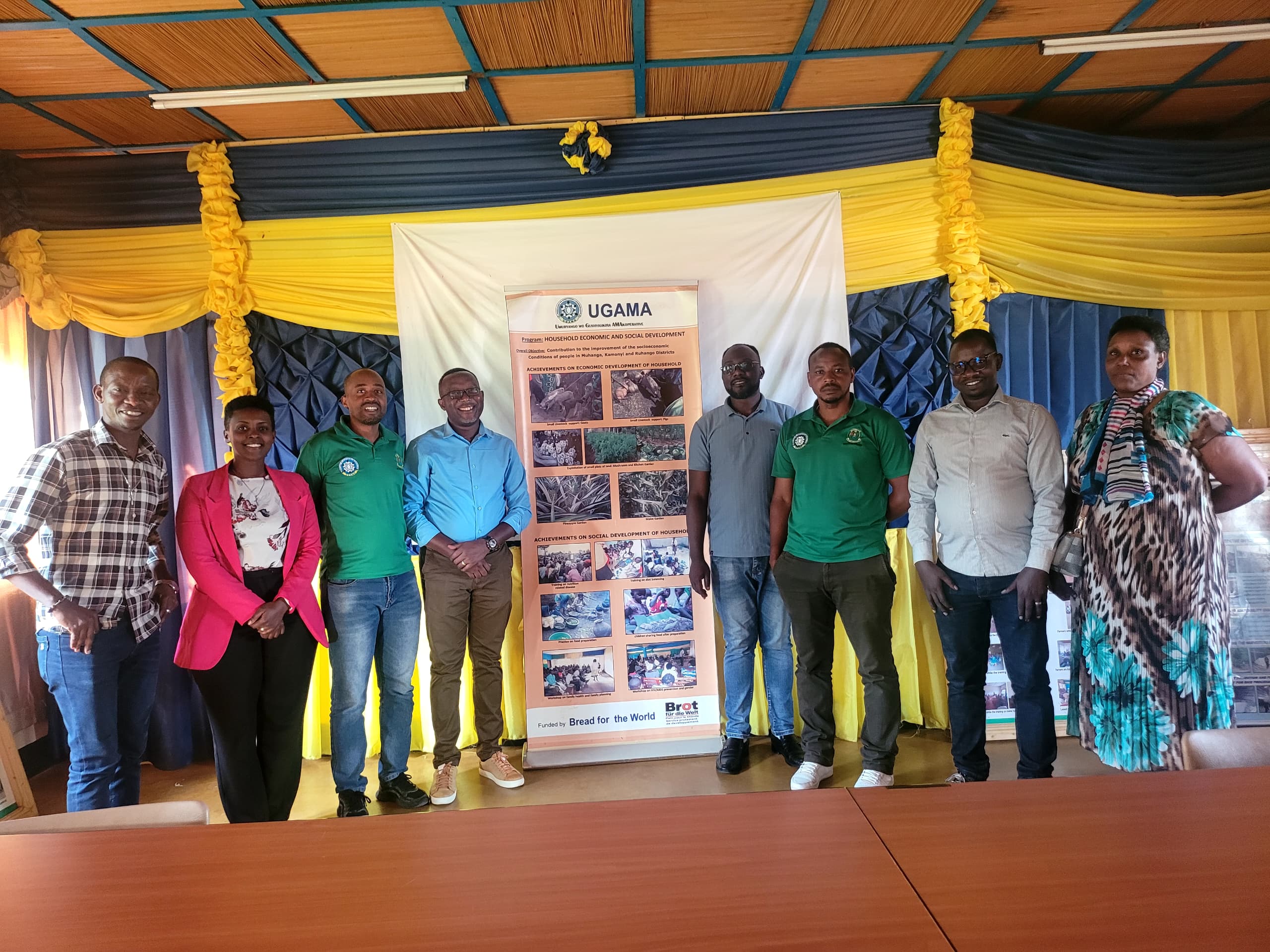
In collaboration with Digital Earth Africa, UGAMA organized a one-day capacity-building workshop for 10 staff members. The training was a follow-up to national engagement efforts under the Information for Agriculture, Food, and Water Security (IAFWS) Project. The session focused on utilizing DE Africa’s maps and sandbox tools to analyse surface water trends, crop health, and plant phenology in Muhanga District, Southern Rwanda.
Detecting Crop Greenness and Health
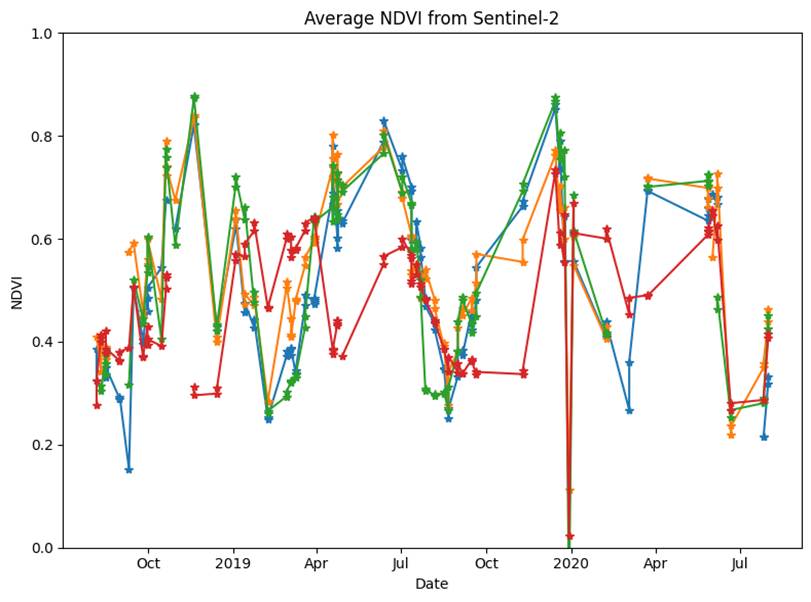
Participants used the Normalized Difference Vegetation Index (NDVI) to examine spatio-temporal changes in vegetation, particularly in irrigated seasonal croplands. The analysis revealed that 2022 had significantly greener croplands compared to 2017, a change attributed to an increase in water availability from a newly expanded dam. Agricultural extensionists from UGAMA confirmed that improved water resources led to higher crop yields.
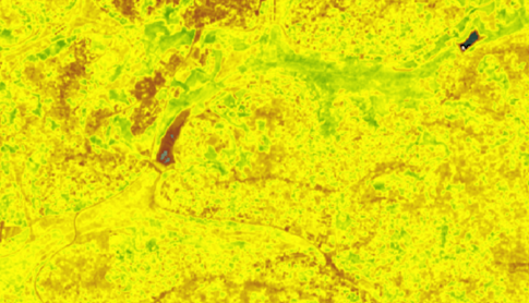
NDVI Comparison of Croplands 2017 (left) vs. 2022 (right)
By utilising DE Africa’s sandbox tool, participants further analysed small-scale crop health trends. Their findings demonstrated that EO tools could provide crucial insights for small-scale farmers, enabling better crop monitoring and yield predictions.
Monitoring Water Resources for Agriculture
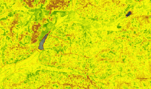
Muhanga District, characterized by limited hydrological networks, relies on several dams for irrigation. The workshop participants used Sentinel-2 GEOMAD data via DE Africa maps to study the dynamics of Shyogwe Dam. Their analysis indicated a direct correlation between increased water extent and improved crop health in 2022.
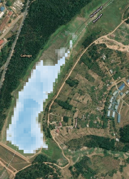
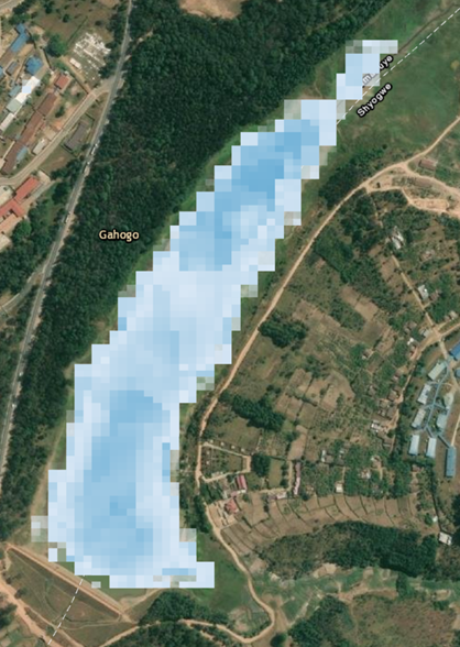
Shyogwe dam (2017-left and 2022-right)
Looking Ahead: EO for Smarter Agricultural Planning
Embracing geospatial technologies promises to reduce human and financial resource constraints while enabling frequent and detailed surveys of large agricultural areas. UGAMA’s leadership expressed enthusiasm about integrating EO into their project planning, monitoring, and evaluation strategies.
Malachie Habanabashaka, UGAMA Coordinator, emphasized the importance of this initiative: “A pilot use case will be co-developed soon not only to test the robustness of DE Africa platforms, but also to initiate the integration of space-based approaches in our projects.”
By adopting EO-based methodologies, UGAMA is set to enhance agricultural sustainability, ensuring that Rwandan farmers are better equipped to face climate challenges and maximize productivity.