 English
  Português
  Français
  العربية
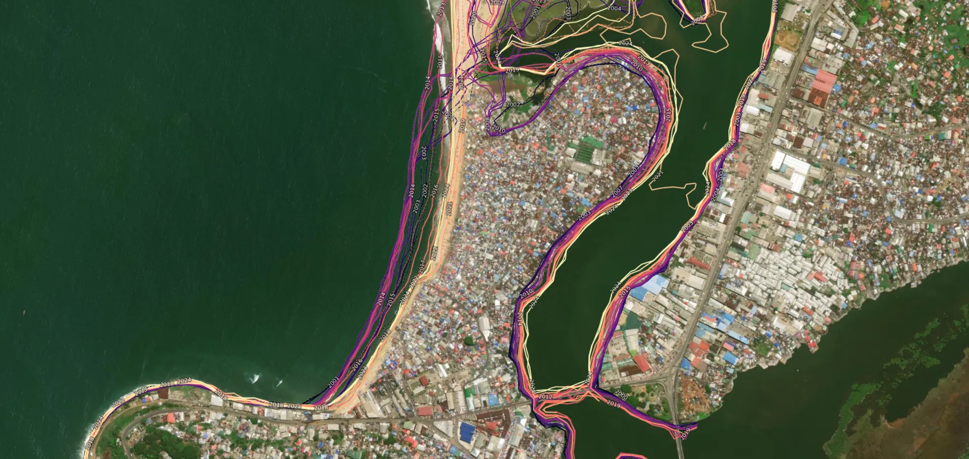
Meeting the challenges of poverty reduction and disaster response requires more than just funds and good intentions. It demands actionable insights drawn from accurate and reliable data. For Walker Kosmidou-Bradley, a Geographer with the Poverty and Equity Global Department at the World Bank, satellite data isn’t merely an analytical tool but a revelatory lens. By integrating Earth observation with traditional household survey methods, new dimensions of the challenges faced by the world’s most vulnerable populations are being illuminated.
Kosmidou-Bradley supports over 20 countries across West and Central Africa. He begins his missions by answering fundamental, yet persistently difficult questions such as, “Where are the poor? Why are communities vulnerable? What targeted interventions are needed to create meaningful change?”
These questions are not just theoretical exercises; they underpin the decisions and investments that determine the futures of millions. However, African governments often lack access to data or remain unaware of the insights they can provide.
Traditional household surveys have long been central to assessing poverty levels. Yet these are slow, costly and typically lack the granularity needed for localised insights. “They offer a broad understanding of trends but rarely zoom in to the community or neighbourhood level, where real problems and real people exist,” explains Kosmidou-Bradley. This is where geospatial data, such as that made available by initiatives like Digital Earth Africa, are helping to bridge the gap.
When Earth observation data meets dire realities
By pairing Earth observation with survey results, Kosmidou-Bradley has managed to make the invisible, visible. Satellite imagery doesn’t merely verify existing challenges; it pinpoints their exact locations and provides policymakers with accessible, visual evidence.
Discussing his experience with coastline changes in Liberia, for example, Kosmidou-Bradley describes how DE Africa helped identify a Monrovia neighbourhood where the sea is submerging homes at an alarming rate. Each block that vanishes into the water leaves already vulnerable families without insurance or means to recover, illustrating a devastating spiral into deeper poverty. Liberia, a country that struggles with 58.9% poverty rate (World Bank. 2023. Liberia Poverty Assessment 2016 – Towards a more inclusive Liberia. © World Bank), cannot readily remediate community catastrophes such as this.
Institutes like the World Bank can provide critical inputs to highlight these issues, and Kosmidou-Bradley believes tools like DE Africa complement this as critical game-changers due to their accessibility. “The platform offers free, open, standardised datasets which don’t demand sophisticated computers or fast internet,” he notes. DE Africa’s tools, including its cloud-based Sandbox, make it possible to work from virtually anywhere. Importantly, these tools support scalability, allowing solutions developed in one country to be quickly adapted and deployed across others with similar challenges.
Take Ghana as an example. While investigating dam-related flooding in the south of the country, satellite imagery overturned assumptions and revealed the most severe flooding and displacement were actually occurring far upstream in the north. This discovery shaped a broader approach to flood mapping, later supported by DE Africa tools like the Water Observations from Space product.
Data beyond the visible
Kosmidou-Bradley highlights how geospatial data is not a replacement for traditional methods but rather an augmentation. Beyond just finding where issues lie, it supports problem-solving by interlinking different sectors. For instance, in Ghana, water data from the south was layered with satellite data revealing upstream flooding, providing actionable insights for health, education, and infrastructure planning. Instead of isolated observations, governments could holistically visualise the true cost of flooding across multiple sectors. This ability to integrate data allows planners to argue convincingly for cost-effective interventions.
“When analysing the data, and tasking a cross-sectoral approach, policymakers can see what and where issues are, for example, a $5 million dollar cost to enact flood prevention remedies, becomes a saving in the long term,” he points out, “especially when the costs of inaction are vividly quantified.” For decision-makers, this holistic understanding often galvanises much-needed action.
The practical efficiencies offered by ready-to-use datasets cannot be understated. Planning becomes quicker, investigations more specific, and outcomes actionable when governments and non-government entities are empowered with tools like DE Africa. Its satellite-derived insights free up users from resource-draining tasks such as downloading, storing and computing raw data, providing them instead with pre-processed datasets tailored for immediate use.
The human element of geospatial innovation
Yet, technology alone isn’t enough. Even with readily available tools and data, there are often organizational and personnel barriers to adoption at the institutional level. While international financial organizations like the World Bank or African Development Bank often focus on skills, computers, and servers, subordinates might avoid undertaking unrequested analyses, and leaders may not request insights they’re unaware exist. Kosmidou-Bradley observes, “Institutional culture can perhaps hinder uptake. People don’t ask for things they don’t know are possible.”
Education and knowledge sharing within systems is crucial. DE Africa, by lowering entry barriers, is part of the solution, but Kosmidou-Bradley emphasises that government bodies, universities, and statistical agencies must collaborate closely to ensure the sustainability and usability of data ecosystems. Equipping local experts and educational institutions encourages demand for data and builds a pipeline of expertise, ensuring data doesn’t sit unused on servers.
Mapping futures with actionable insight
Data can no longer live in silos. Whether addressing poverty, responding to flooding, or preventing mass displacement, geospatial innovation bridges gaps that previously left the most vulnerable populations unseen and unsupported. Governments and global stakeholders stand before a unique opportunity to leverage platforms such as Digital Earth Africa in tackling problems with precision, strategy, and compassion.
However, as Kosmidou-Bradley highlights, the ultimate goal extends beyond simply delivering data. For sustainable change, it’s about fostering ecosystems where data drives imagination, amplifies human decision-making, and truly transforms lives. There’s no time to waste; the more informed and efficient our decisions, the greater our capacity to make meaningful, equitable change.
Walker Kosmidou-Bradley has provided insights and opinion that are entirely his own and in no way reflect the stance, opinion or advice of the World Bank.