 English
  Português
  Français
  العربية
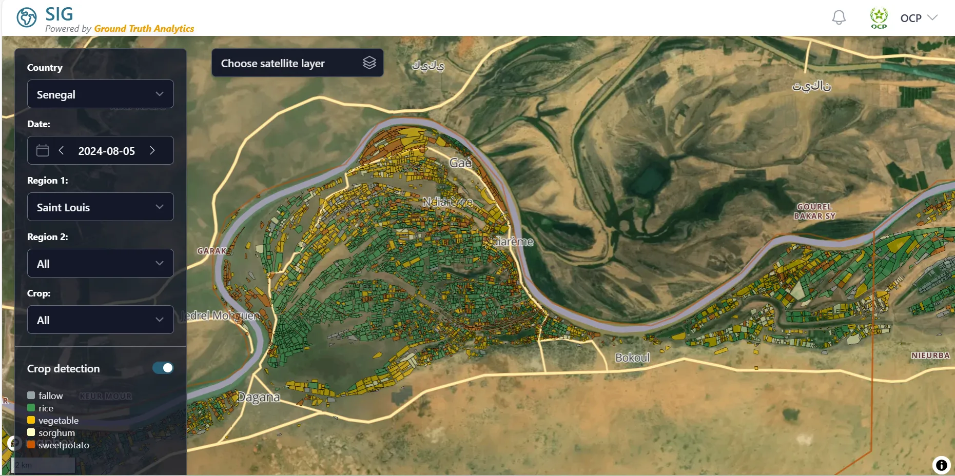
Across Africa, agriculture is being invigorated through the power of data, artificial intelligence, and satellite technology. One of those companies leading the charge is Ground Truth Analytics, a subsidiary of University Mohammed VI Polytechnic (UM6P), headquartered in Morocco. Their mission is to translate complex agricultural datasets into practical actions that help smallholder farmers thrive and food systems evolve, both sustainably and at scale.
Ground Truth Analytics’ work spans multiple disciplines such as soil science, geospatial technology, AI, and field-based agronomy to scale this work across vast geographies. Additionally, Digital Earth Africa’s open, analysis-ready Earth observation datasets provide a key part of the offering.
Building intelligence for agriculture, one data point at a time
UM6P’s vision recognises that improving soil health and optimising fertiliser use are critical to Africa’s agricultural productivity. But to provide farmers with the right fertiliser formulas, two types of data are essential: soil fertility and crop type. While significant strides in mapping soil characteristics across the continent have been made, it was evident that a huge opportunity lay in the provision of reliable, large-scale crop monitoring systems to further support agricultural endeavour across the continent.
Ground Truth Analytics was originally established as a subsidiary of UM6P to meet this need. Over the last few years, the organisation has engaged with more than 16 governments across the continent as it has gone about developing a geospatial intelligence agricultural platform. The system combines satellite imagery, AI models and extensive ground data to deliver insights. The objective is twofold: to help farmers take timely, data-based actions that will ensure successful crop outcomes; and to provide data to institutions such as banks and insurance companies that support and finance farming efforts. The overall goal is to promote sustainable and successful farming practices throughout the continent while opening up avenues to capital and derisking agricultural lending.
To train their models, Ground Truth Analytics worked in partnership with OCP Africa, a subsidiary of OCP Group, the world’s largest exporter of phosphate fertilisers headquartered in Morocco and numerous governments across Africa, deploying over 1,000 field agents to collect data across millions of farms. The result is a library of more than 2 million data points, covering everything from crop type to phenological stages. This is the foundation for Ground Truth Analytics’ digital tools which are being used by governmental agencies, financial institutions, and agricultural cooperatives to guide interventions and improve outcomes on the ground.
The role of Digital Earth Africa: enabling access to satellite intelligence
In this highly technical ecosystem, Digital Earth Africa has been used as a key resource. Through its cloud-hosted platform, Digital Earth Africa provides open access to analysis-ready satellite imagery. Specific to Ground Truth Analytics’ needs is the Sentinel-1 radar data, for its crop classification work.
“Sentinel-1 data helped us improve model accuracy by around five percent,” says Driss Lahlou Kitane, CEO of Ground Truth Analytics. “That kind of gain makes a real difference when operating at scale across millions of hectares.”
Unlike optical satellite imagery, radar data can penetrate cloud cover which is a significant advantage in tropical regions like southern Nigeria, coastal Ghana, and equatorial Kenya, where cloudiness can persist through entire growing seasons. The pre-processed, analysis-ready Sentinel-1 data available via Digital Earth Africa reduces the burden of technical processing, enabling Ground Truth Analytics’ team to focus on model development, dashboard delivery, and farmer engagement.
While Ground Truth Analytics also uses other data sources, including Sentinel-2 and internally developed pipelines, the integration of Digital Earth Africa data has proven particularly valuable in boosting the reliability and completeness of their models.
From governments to farmers
The downstream applications of this technology are where the story comes alive. For example, in Ghana, Ground Truth Analytics is working with agricultural cooperatives to support smallholder farmers directly. Through a mobile application, cooperative leaders can remotely monitor hundreds of farms, verify that best practices are being followed, and guide farmers throughout the season. The farmers themselves receive custom notifications: when to plant, when to apply fertiliser, and how to respond to emerging pest threats, which are often tailored to the specific phenological stage of their crops.
In East Africa, the organisation is partnering with the banking system to support credit scoring for smallholder farmers. By analysing satellite imagery over time, a bank can evaluate a farmer’s historical land use, presence of water bodies, and cropping rotation practices. This not only opens access to credit for more farmers, but also reduces the risk for the lending institution, creating a win-win scenario.
An African-led innovation story
Ground Truth Analytics reflects UM6P’s broader model, where research is not siloed in publications but directed toward platforms, prototypes, and policies that solve structural challenges. Crucially, while the technologies are advanced, the approach is rooted in local partnerships and a commitment to African-led innovation. Ground Truth Analytics customises its solutions to local contexts, whether working through ministries of agriculture, private input suppliers, or community-based cooperatives.
Ground Truth Analytics shares a similar ethos with Digital Earth Africa given the goal to democratise access to Earth observation data and empower African stakeholders to use it independently; from flood monitoring to land-use planning and, of course, agriculture.
“Digital Earth Africa plays an important role in helping us reach our goals more efficiently,” Driss notes, “with the availability of quality, pre-processed radar imagery having been a real accelerator.”
Scaling solutions to broaden impact
Now emerging from its development phase, Ground Truth Analytics is actively expanding its reach. It is onboarding new countries, new partners, and new user groups. Whether supporting fertiliser suppliers, banks, or national extension services, the organisation is proving that geospatial intelligence, when paired with on-the-ground relationships, can transform agricultural systems from the roots up.
And while satellite data may orbit hundreds of kilometres above the Earth, its impact is being felt directly in farmers’ fields, where better decisions lead to better harvests, stronger economies, and a more food-secure Africa.