 English
  Português
  Français
  العربية
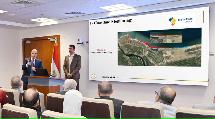
In a pioneering move to strengthen national water security, Egypt’s Ministry of Water Resources and Irrigation (MWRI) has begun harnessing the capabilities of Digital Earth Africa to monitor and manage its coastal zones. This initiative, led by His Excellency Professor Hani Sewilam, Minister of Water Resources and Irrigation, forms a central component of Egypt’s 2050 Water Resources Strategy, specifically under the Irrigation System 2.0 plan.
The Irrigation System 2.0 plan marks a strategic shift beyond traditional water management, integrating advanced digital tools and platforms under its “smart management” pillar. According to Eng. Walid Hakiki, Head of the Planning Sector at MWRI, the ministry is actively developing mobile applications and web-based systems using cutting-edge technologies such as remote sensing, geographic information systems (GIS), and numerical modelling.
“Our goal is to equip ministry agencies with the latest tools for efficient planning and monitoring,” Hakiki explained. “We’re building systems that are not only data-driven but also user-friendly and scalable.”
Following the instructions of Minister Sewilam, a specialized team of MWRI scientists has been exploring the use of Digital Earth Africa to support national water management objectives. The platform has proven instrumental for several applications, including shoreline monitoring, water quality assessment, land cover classification, and irrigation network management.
One of the key successes has been the use of Digital Earth Africa’s coastline service to monitor over 2,000 kilometres of Egypt’s coastline. By analysing shoreline changes from 2000 to 2023 at 30-meter intervals, the ministry has been able to evaluate the performance of existing shoreline protection structures, identify high-risk erosion zones and detect deposition areas where natural sediment accumulation is forming new landforms such as beaches, spits, and sandbars
These insights were further validated through field assessments conducted by the Egyptian General Authority for Shore Protection.
“The coastline service has provided us with extremely detailed insights into shoreline evolution over the past 23 years,” stated the MWRI team. “This has been incredibly useful. Since the initial investigations, the General Authority has also adopted the platform for ongoing monitoring.”
In addition to shoreline analysis, the MWRI team is now expanding the use of Digital Earth Africa’s other capabilities, including water Observations from Space (WOfS) and fractional cover monitoring.
What sets Digital Earth Africa apart, the ministry notes, is its accessibility. Its intuitive visual interface allows non-technical users to extract and interpret complex satellite data with ease. Moreover, the platform’s open-source algorithms and APIs make integration with external systems seamless.
Egypt’s adoption of Digital Earth Africa reflects its broader commitment to technological innovation and integrated coastal zone management as part of its long-term strategy for water sustainability. As the Irrigation System 2.0 plan progresses, such digital platforms are expected to play an increasingly vital role in shaping Egypt’s climate resilience and water governance for decades to come.