English
  Português
  Français
  العربية
 Digital Earth Africa
Cropland Extent Map
Unlocking Africa’s Agricultural Potential through the Cropland Extent Map
Spatial information on cropping systems can assist with managing food insecurity. This includes data sets on agricultural water use, crop types, and crop productivity. These applications require information on the location and extent of cropland. Digital Earth Africa’s Cropland Extent map is a provisional service for the year 2019, which maps the presence and absence of crops at a 10-metre pixel resolution for the entire African continent.
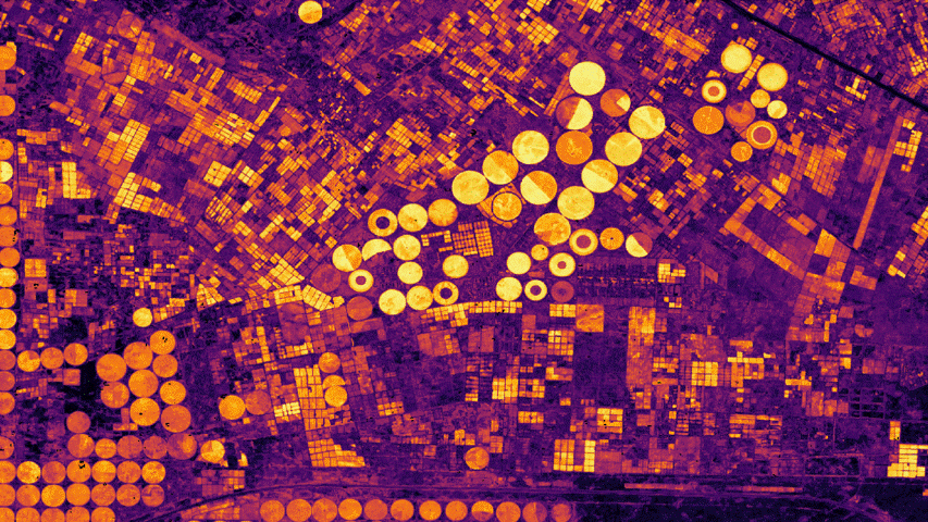
Probability of cropping in the Nile Delta, with yellow indicating crops, processed by Digital Earth Africa.
Key Features
Agricultural Analytics
Provides an indication of the presence or absence of crops and offers a precursor to understanding the dynamics of crop activities.
High Resolution
The product is developed specifically for the African context, and provides continental-scale coverage. Identifying the presence or absence of crops at a 10-metre pixel resolution, the Service maps small and irregular fields which are prevalent across Africa.
Key Measurements
The Cropland Extent includes a binary presence/absence layer, a probability layer indicating the probability that a pixel is cropland, and a filtered layer. The probability layer can be used as a proxy for the uncertainty of the classification while the object-based filtered layer provides a smoother classification output by merging areas likely to be cropland.
Digital Earth Africa
Measuring Crop Health
The crop health notebook illustrates how Earth observations can be used to measure plant health over time, and to identify any changes in growth patterns between otherwise similar fields. Identifying under-performing fields enables farmers to undertake management action. The notebook shows three areas for comparison; croplands in Senegal and Western Kenya, and a coffee farm in Tanzania.
Applications
Planning & Policymaking
Cropland extent maps provide crucial data to planners and policymakers about agricultural areas, and can be used as a starting point for monitoring agricultural production.
Accurate Resource Allocation
Understanding the spatial distribution of agricultural areas is important for managing natural resources to preserve biodiversity while supporting livelihoods and economic development.
Powerful Overview Functionality
The cropland extent map is an essential input to precision land management including the estimation of agricultural variables such as soils, irrigation, and yield.
Related Use Cases

March 4, 2026
DE Africa and Sôlt Africana collaborate to strengthen agricultural verification and EUDR compliance

January 27, 2026
Lebogang explores non-perennial rivers and food security through Earth observation