 English
  Português
  Français
  العربية
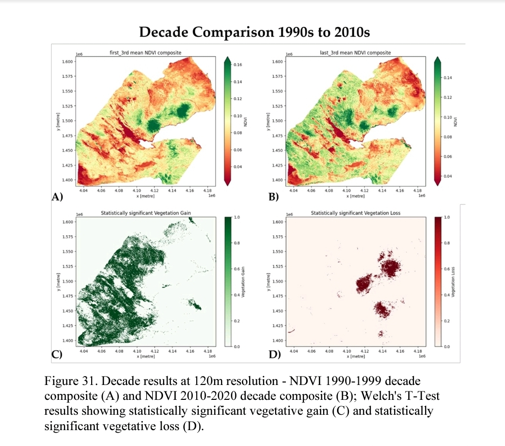
In an era where satellite data is reshaping how we understand our world, access and usability remain the biggest hurdles for many would-be users. That’s where Digital Earth Africa (DE Africa) is turning the tide – by democratising satellite data access and making advanced Earth observation tools available to everyone, regardless of their coding background.
Julee Wardle, a geospatial scientist and researcher with a passion for ecological monitoring and public good science, is one such user who exemplifies the new wave of empowered data explorers. Through Digital Earth Africa, Julee was able to dive into satellite-derived vegetation data without needing to master complex coding languages or wrangle raw satellite imagery.
“I would not class myself as a highly experienced Python coder,” Julee explained. “But with DE Africa, I didn’t need to be. The datasets are already pre-processed and ready to use, and the tools are intuitive. Not only was I able to quickly grasp the coding requirements, but I was also able to interrogate and configure vast amounts of data from my laptop, while sitting in my local coffee shop without having to spend hours pre-processing data in a sophisticated lab environment.”
DE Africa’s platform removes many traditional barriers. Historically, accessing satellite data meant managing vast volumes of raw data, understanding sophisticated preprocessing methods, and often needing cloud computing resources or advanced programming skills. A combination of leveraging the Open Data Cube (ODC) technology of which DE Africa is the largest operator – and cloud-based Sandbox environment, users can visualise and work with analysis-ready data with ease – right from a browser. The ODC is a not-for-profit open-source project and community, that was created and is facilitated by the Committee on Earth Observation Satellites (CEOS), with the Australian Geoscience Data Cube as its initial implementation.
Investigating food insecurity in African
Julee’s research focused on the arid landscapes of Djibouti, a small but strategically located country in the Horn of Africa. Djibouti faces chronic food insecurity, driven by its harsh climate, extremely limited arable land, and high dependence on food imports. With less than 1% of its land suitable for cultivation and recurring droughts, sustainable local food production is a significant challenge.
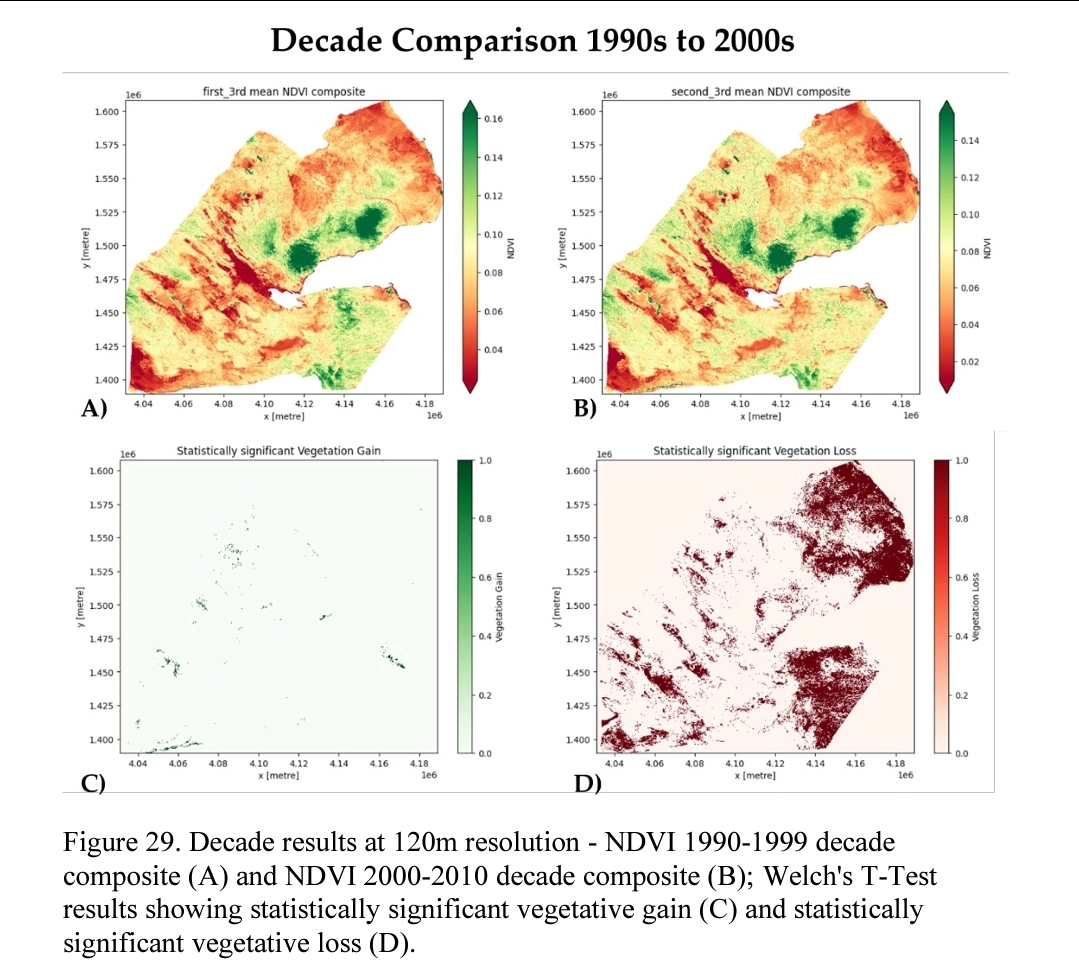
In this context, understanding patterns of vegetation growth – even sparse vegetation – is critical. Julee turned to DE Africa’s Fractional Cover datasets, which provide detailed insights into the ground cover: photosynthetic vegetation, non-photosynthetic vegetation, and bare soil. These datasets, updated regularly and available across time series, allow researchers to observe how ecosystems respond to seasonal variations and long-term climate pressures.
Using these tools, Julee was able to:
- Access 30 years of years of historical vegetation data for targeted study areas in Djibouti and beyond.
- Identify regions where natural vegetation resilience appeared stronger than expected, particularly around seasonal wetlands and floodplains.
- Understand shifts in land cover that could inform strategies for sustainable land management and targeted reforestation or greening initiatives.
These insights are more than academic. They could support policy decisions around land use, help prioritise areas for ecological restoration or even guide humanitarian responses in food-insecure zones.
“It really changes the game,” said Julee. “It means people can focus on the science, the questions, the impact – instead of spending all their time on the technical setup.”
That’s precisely DE Africa’s mission: to make Earth observation data accessible and useful for decision-makers, researchers, NGOs, and communities across the continent. With datasets that span the entire African continent and tools that are open and accessible, the platform invites a new kind of user: one driven by curiosity and impact – not necessarily only those with deep technical expertise.
Whether monitoring deforestation, tracking floods, or mapping vegetation changes in some of the world’s most climate-vulnerable regions, DE Africa provides the building blocks so users like Julee can focus on solutions, not the setup.
Aligning with national climate and development policies
Julee’s work using DE Africa is timely – not just scientifically, but politically. Djibouti’s national development agenda prioritises climate resilience and sustainable resource management, with a growing role for Earth observation.
- Through the National Adaptation Programme of Action (NAPA) and SCAPE strategy, the government has committed to improving resilience in agriculture, water, and rural livelihoods.
- The Djibouti ICI Plan (2020–2024) highlights digital innovation and environmental stewardship as key to inclusive economic growth.
- Djibouti also recently undertook its first national Earth observation mission in partnership with France, signalling a clear investment in space-based monitoring and geospatial data services.
By leveraging DE Africa’s pre-processed, freely accessible datasets, researchers like Julee could directly contribute to these national objectives by bringing scientific insight to bear on policies for food security, drought mitigation, and land restoration.
As an active enabler of closing Africa’s digital divide and making open data initiatives more accessible, from academic treatise through to application in real-world scenarios, Digital Earth Africa offers a powerful reminder: making satellite data accessible doesn’t just broaden participation – it accelerates progress where it’s needed most.