 English
  Português
  Français
  العربية
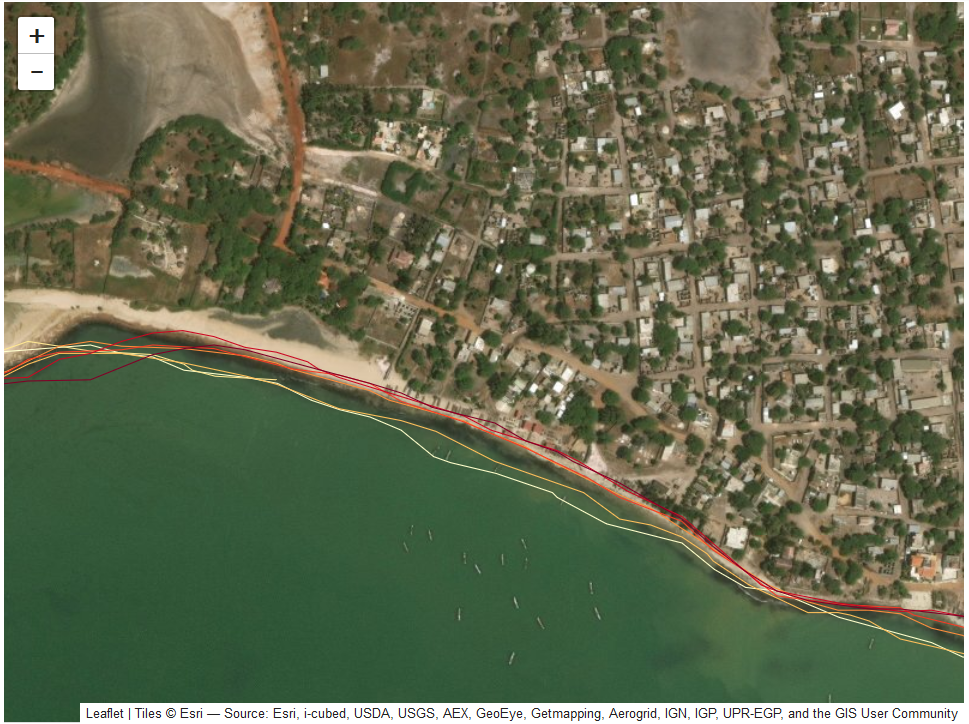
Senegal’s coastline stretches more than 718 kilometres. It is home to fishing communities, mangrove forests, tourist resorts, and major ports. It is also eroding in some places, dramatically so. Satellite data shows that parts of the Kafountine coastline in southern Senegal are retreating at rates exceeding 26 metres per year. In the Kalone Bliss Kassa Marine Protected Area, the shoreline has shifted by an average of nearly 101 metres over just 34 years.
These statistics represent homes, livelihoods, farmland, and ecosystems at risk. Responding to this crisis requires political will, community action, and reliable, up-to-date scientific data and the tools to turn that data into decisions.
That is where the partnership between Digital Earth Africa and Senegal’s Centre de Suivi Ecologique (CSE) comes in.
A Partnership Built on Open Data and Shared Purpose
Digital Earth Africa is a continental Earth observation programme that transforms satellite data into actionable insights for African governments, researchers, and development practitioners. CSE, Senegal’s Ecological Monitoring Centre operating under the Ministry of Environment and Ecological Transition, is one of West Africa’s foremost institutions for coastal science, governance support, and field-level environmental action.
Together, the two organisations have worked to bring the power of satellite-based coastal monitoring directly into the hands of the people who manage Senegal’s shoreline.
At the heart of this collaboration is DE Africa’s Coastlines Monitoring Service, an open-access product that uses Landsat and Sentinel satellite data to map annual shoreline positions and measure rates of erosion and accretion along coastlines across the African continent. For Senegal and the broader West African region, CSE has played a central role in validating this tool, training institutions in its use, and integrating its outputs into national and regional coastal planning frameworks.
Putting the Tool to Test
Satellite-derived data is only as useful as it is accurate. CSE conducted a rigorous, two-phase validation of the DE Africa Coastlines algorithm to confirm that it could be trusted for operational decision-making along West African coasts.
The first phase was regional, covering all 12 member countries of the Regional Observatory for the West African Coastline (ORLOA), a body that CSE has coordinated since 2018 under the West Africa Coastal Areas (WACA) programme among others. Very high-resolution satellite imagery was used as a reference benchmark against which DE Africa Coastlines outputs were tested.
The second phase was conducted along the Senegalese coast itself, combining drone surveys producing centimetre-resolution orthomosaics with DGPS ground surveys for precise field measurement. The comparison between DE Africa Coastlines data and field measurements confirmed that the tool extracts shoreline positions and rates of change with high precision thus validating it as a scientifically robust product suitable for coastal planning and risk management.
This validation work mattered beyond Senegal. It helped establish DE Africa’s Coastlines as a credible regional tool across West Africa and contributed directly to the harmonisation of coastal monitoring approaches among ORLOA member states.
From Data to Decision-Making
Validation alone does not drive change. CSE invested equally in ensuring that the tool was understood and used by the institutions that need it most.
At the regional level, workshops brought together ORLOA member countries to share methodology, exchange results, and align their approaches to shoreline monitoring. At the national level, training sessions drew in universities, research centres, line ministries, and technical directorates thereby giving a wide range of practitioner’s hands-on access to DE Africa’s platform, and building their capacity to extract, interpret, and apply coastal data in territorial planning and risk management processes.
The result has been the consolidation of a regional network of coastal expertise, and a measurable strengthening of institutional capacity to use Earth observation data for sustained coastal governance.
Science in Service of Communities
The DE Africa and CSE partnership sits within a much broader CSE effort to protect Senegal’s coastline and the communities that depend on it. Across multiple projects including WACA, CSE has deployed satellite data alongside nature-based solutions, community mobilisation, and governance support.
In the Casamance region, shoreline change analysis using DE Africa derived data informed the deployment of Maltais Savard groins, lightweight foliage interwoven wooden structures that trap sand and rebuild eroding beaches. Ten were installed at Diembering and seven at Pointe Saint Georges, with visibly positive results. In the Langue de Barbarie Marine Protected Area near Saint-Louis, typha palisades helped reconstitute protective coastal dunes, benefiting around 200 farming families and enabling the return of 52 bird species by 2023.
In every case, reliable data on how the coastline is changing has been foundational to designing and targeting these interventions.
The Scale in Numbers
The scale of the coastal challenge in Senegal is significant. Studies conducted in the communes of Bargny, Gandon, Kafountine, and Yene found erosion rates ranging from -0.21 to -5.58 metres per year. Projections suggest rates could reach -111.6 metres per year in Saloulou (Kafountine) by 2044. Between 70 and 93 percent of households in these communities lack formal documentation of their land rights, compounding their vulnerability.
The Community Vulnerability Index recorded its highest value at Bargny (255), compared to Gandon (160), Yene (149), and Kafountine (125), a measure of how intertwined coastal erosion, food insecurity, and social fragility have become.
These figures underscore why the partnership between a continental data platform like DE Africa and a grounded national institution like CSE is so consequential. Data without local expertise cannot reach the people who need it. Local expertise without reliable data cannot make the case for investment and policy change. The two are stronger together. For DE Africa, the partnership with CSE represents the kind of national implementation that gives continental satellite tools their real-world value: grounded validation, institutional embedding, capacity transfer, and direct connection to the communities and ecosystems that the data is ultimately meant to serve.
Read the full Centre De Suivi Écologique report.