 English
  Português
  Français
  العربية
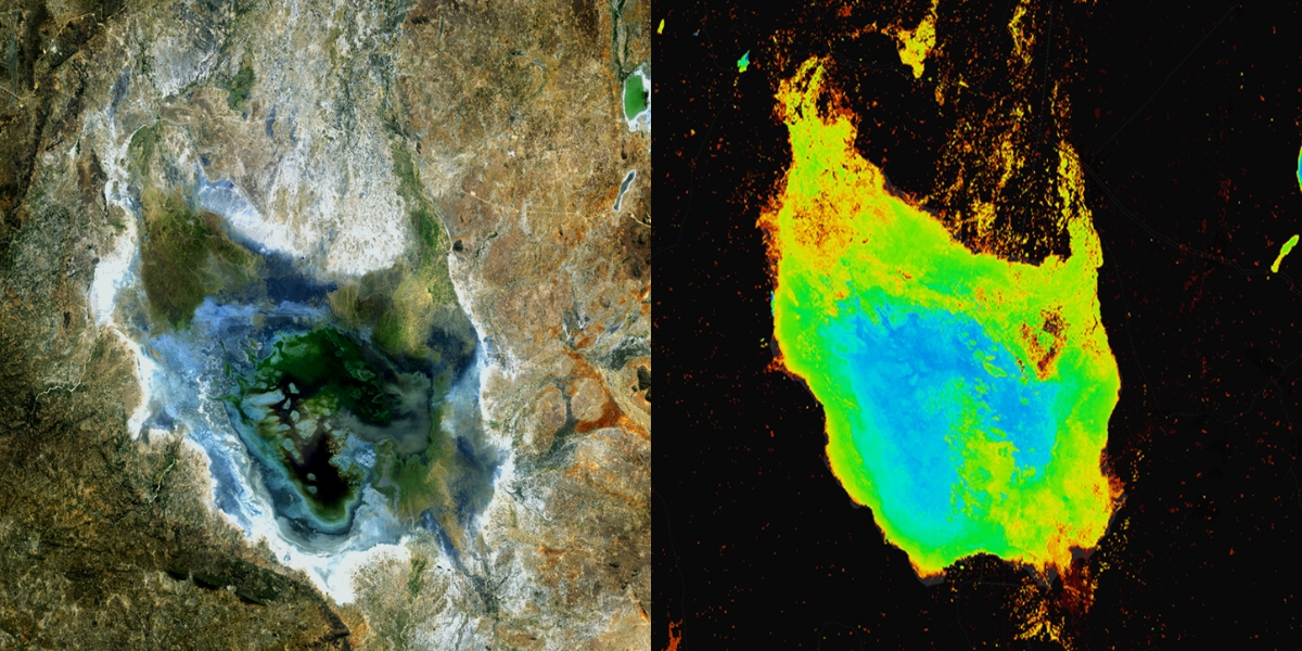
Across Africa, lakes and wetlands quietly support the systems people rely on every day. They sustain ecosystems, support farming, regulate water flows, and provide livelihoods for nearby communities. Yet many of these water bodies are changing. Some are shrinking, others fluctuate more dramatically than before, and in many places the long-term trends are not always easy to see from the ground. Satellite Earth observation offers a way to step back and view these changes over time.
Using data and tools available through Digital Earth Africa, researcher Nancy Wayua analysed long-term changes in the surface water extent of Lake Sulunga in central Tanzania. Her work demonstrates how decades of satellite imagery can reveal patterns in water dynamics that would otherwise be difficult to track.
Lake Sulunga plays an important role in the surrounding landscape. Like many lakes in East Africa, it supports nearby ecosystems and communities while responding to seasonal rainfall patterns and broader environmental pressures. Changes in rainfall, land use within the catchment, and water extraction can all influence how the lake expands or contracts over time. Understanding these dynamics is important for sustainable water management, but consistent long-term records are often limited.
To examine these changes, Wayua used Water Observations from Space (WOfS), a dataset available through Digital Earth Africa that maps surface water across the continent. WOfS is derived from imagery captured by Landsat satellites and provides a historical record of where water has been detected across Africa over time. For the Lake Sulunga analysis, annual summary data spanning more than three decades, from 1990 to 2024, was explored using the Digital Earth Africa Sandbox, a cloud-based analysis environment that allows users to process large volumes of satellite data.
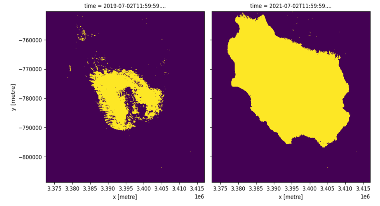
The workflow began by defining the geographic boundary around Lake Sulunga and extracting WOfS data for that region. By clipping the dataset to the lake’s precise area of interest, the analysis focused only on the water body itself. Using Python-based tools available in the Sandbox environment, the workflow then calculated the lake’s annual water extent by identifying and counting pixels classified as water for each year.
The results provide a clear picture of how Lake Sulunga’s surface water area has changed over time. A time series of annual water extent shows noticeable fluctuations between 1990 and 2021, with periods where the lake expanded and others where its water coverage contracted. These variations reflect the complex interplay of rainfall patterns, climate variability, and environmental pressures affecting the region.
Comparing specific years helped highlight where these changes occurred across the lake’s surface. For example, an analysis comparing water extent in 2019 and 2021 revealed areas where water had expanded, areas where previously wet zones had dried, and locations where water remained stable across both years. These spatial insights help illustrate not just how much the lake changed, but where those changes happened.
To further explore these dynamics, the analysis also produced an animated visualisation showing annual water frequency across the lake. Watching the patterns shift year by year makes it easier to see how the lake’s water presence has varied across decades, offering a powerful visual perspective on environmental change.
This analysis highlights the value of combining long-term satellite data with accessible analysis platforms. With tools like Digital Earth Africa, researchers, governments, and environmental practitioners can monitor water bodies consistently over time and generate evidence to support better decision-making.
The approach used for Lake Sulunga is not limited to a single location. Because the WOfS dataset covers the entire African continent, similar workflows can be applied to monitor other lakes, wetlands, rivers, and reservoirs. As pressures on water resources continue to grow, the ability to track changes across these critical ecosystems will become increasingly important.
By turning decades of satellite observations into clear insights, analyses like this one show how Earth observation data can help deepen our understanding of Africa’s changing landscapes and support more informed management of the continent’s vital water resources.
Try It Yourself
Digital Earth Africa’s Sandbox environment and the WOfS Annual Summary dataset are freely available to anyone working on water monitoring, environmental assessment, or land use change analysis in Africa. Whether you are a government analyst, a researcher, or a conservation practitioner, the platform provides the tools to turn decades of satellite data into actionable insight.
To get started with DE Africa and explore the WOfS product, visit:
https://www.digitalearthafrica.org
Notebooks, documentation, and training resources are available through the DE Africa Sandbox to help you replicate and build on workflows like this one.